You are here: Home > Network List > TD - TransAlta Monitoring Network Stations List
> Station TD009 Z > Earthquake Result Viewer
TD009 Z - Earthquake Result Viewer
| Earthquake location: |
Near Coast Of Ecuador |
| Earthquake latitude/longitude: |
-0.5/-80.3 |
| Earthquake time(UTC): |
2017/12/03 (337) 11:19:06 GMT |
| Earthquake Depth: |
25 km |
| Earthquake Magnitude: |
6.0 Mww |
| Earthquake Catalog/Contributor: |
NEIC PDE/us |
|
| Network: |
TD TransAlta Monitoring Network |
| Station: |
TD009 Z |
| Lat/Lon: |
52.32 N/116.32 W |
| Elevation: |
1335 m |
|
| Distance: |
60.7 deg |
| Az: |
335.531 deg |
| Baz: |
137.563 deg |
| Ray Param: |
0.061337 |
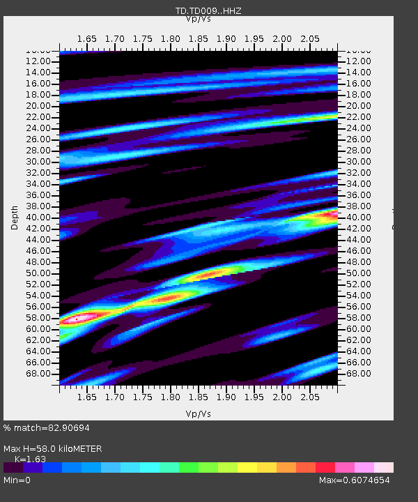
| Estimated Moho Depth: |
58.0 km |
| Estimated Crust Vp/Vs: |
1.63 |
| Assumed Crust Vp: |
6.142 km/s |
| Estimated Crust Vs: |
3.768 km/s |
| Estimated Crust Poisson's Ratio: |
0.20 |
|
| Radial Match: |
82.90694 % |
| Radial Bump: |
343 |
| Transverse Match: |
62.095127 % |
| Transverse Bump: |
395 |
| SOD ConfigId: |
13570011 |
| Insert Time: |
2019-04-29 08:59:02.185 +0000 |
| GWidth: |
2.5 |
| Max Bumps: |
400 |
| Tol: |
0.001 |
|

Signal To Noise
| Channel | StoN | STA | LTA |
| TD:TD009: :HHZ:20171203T11:28:44.460024Z | 2.8943865 | 4.0539257E-7 | 1.4006166E-7 |
| TD:TD009: :HH1:20171203T11:28:44.460024Z | 0.8795813 | 1.7612463E-7 | 2.0023691E-7 |
| TD:TD009: :HH2:20171203T11:28:44.460024Z | 2.2702565 | 2.2356625E-7 | 9.84762E-8 |
| Arrivals |
| Ps | 6.2 SECOND |
| PpPs | 24 SECOND |
| PsPs/PpSs | 30 SECOND |


