You are here: Home > Network List > TA - USArray Transportable Network (new EarthScope stations) Stations List
> Station O17K Koliganek, Bristol Bay, AK, USA > Earthquake Result Viewer
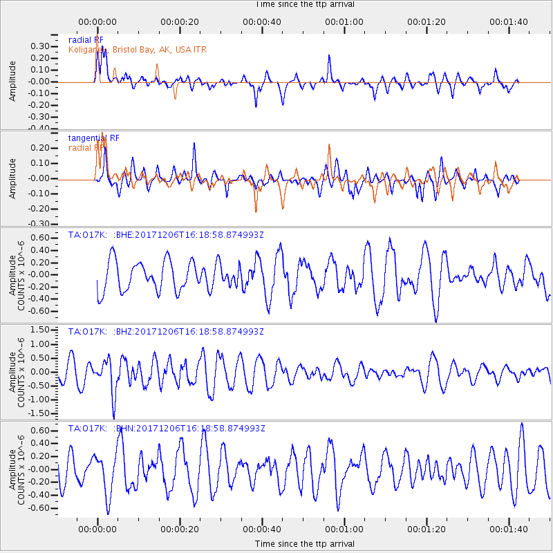
O17K Koliganek, Bristol Bay, AK, USA - Earthquake Result Viewer
*The percent match for this event was below the threshold and hence no stack was calculated.
| Earthquake location: |
Minahassa Peninsula, Sulawesi |
| Earthquake latitude/longitude: |
-0.6/123.7 |
| Earthquake time(UTC): |
2017/12/06 (340) 16:06:55 GMT |
| Earthquake Depth: |
18 km |
| Earthquake Magnitude: |
5.6 mb |
| Earthquake Catalog/Contributor: |
NEIC PDE/us |
|
| Network: |
TA USArray Transportable Network (new EarthScope stations) |
| Station: |
O17K Koliganek, Bristol Bay, AK, USA |
| Lat/Lon: |
59.77 N/157.09 W |
| Elevation: |
156 m |
|
| Distance: |
85.1 deg |
| Az: |
29.925 deg |
| Baz: |
260.384 deg |
| Ray Param: |
$rayparam |
*The percent match for this event was below the threshold and hence was not used in the summary stack. |
|
| Radial Match: |
66.357506 % |
| Radial Bump: |
400 |
| Transverse Match: |
49.038956 % |
| Transverse Bump: |
400 |
| SOD ConfigId: |
13570011 |
| Insert Time: |
2019-04-29 09:12:13.777 +0000 |
| GWidth: |
2.5 |
| Max Bumps: |
400 |
| Tol: |
0.001 |
|
Signal To Noise
| Channel | StoN | STA | LTA |
| TA:O17K: :BHZ:20171206T16:18:58.874993Z | 1.8881744 | 6.1635507E-7 | 3.264291E-7 |
| TA:O17K: :BHN:20171206T16:18:58.874993Z | 1.5720226 | 3.3049986E-7 | 2.1023864E-7 |
| TA:O17K: :BHE:20171206T16:18:58.874993Z | 0.6893847 | 1.7030138E-7 | 2.4703388E-7 |
| Arrivals |
| Ps | |
| PpPs | |
| PsPs/PpSs | |


