You are here: Home > Network List > TA - USArray Transportable Network (new EarthScope stations) Stations List
> Station T33K Petersburg, AK, USA > Earthquake Result Viewer
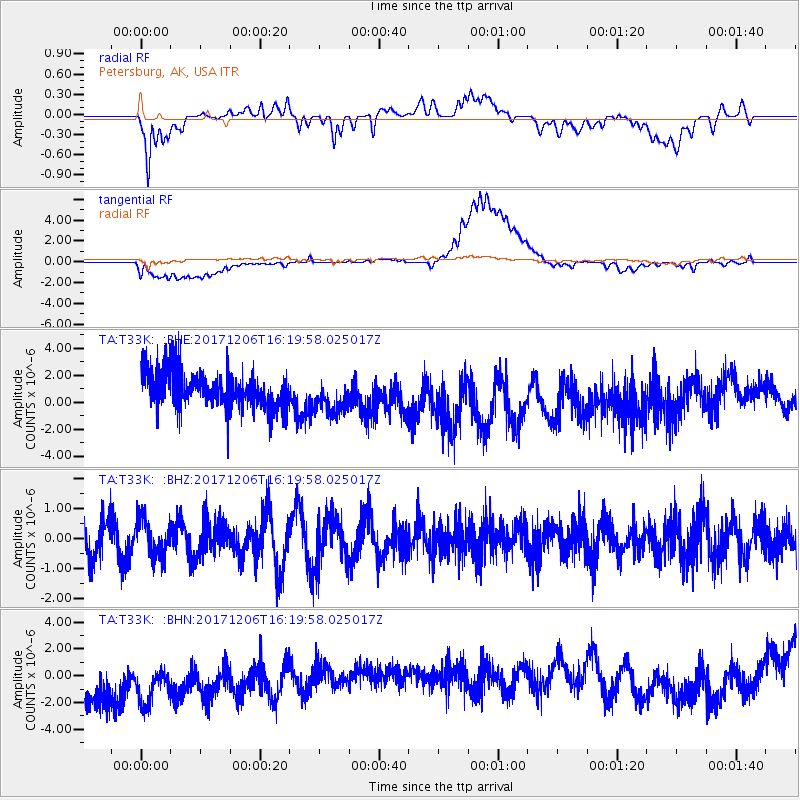
T33K Petersburg, AK, USA - Earthquake Result Viewer
*The percent match for this event was below the threshold and hence no stack was calculated.
| Earthquake location: |
Minahassa Peninsula, Sulawesi |
| Earthquake latitude/longitude: |
-0.6/123.7 |
| Earthquake time(UTC): |
2017/12/06 (340) 16:06:55 GMT |
| Earthquake Depth: |
18 km |
| Earthquake Magnitude: |
5.6 mb |
| Earthquake Catalog/Contributor: |
NEIC PDE/us |
|
| Network: |
TA USArray Transportable Network (new EarthScope stations) |
| Station: |
T33K Petersburg, AK, USA |
| Lat/Lon: |
56.81 N/132.95 W |
| Elevation: |
22 m |
|
| Distance: |
97.8 deg |
| Az: |
32.686 deg |
| Baz: |
280.905 deg |
| Ray Param: |
$rayparam |
*The percent match for this event was below the threshold and hence was not used in the summary stack. |
|
| Radial Match: |
57.717583 % |
| Radial Bump: |
400 |
| Transverse Match: |
40.864353 % |
| Transverse Bump: |
400 |
| SOD ConfigId: |
13570011 |
| Insert Time: |
2019-04-29 09:12:20.922 +0000 |
| GWidth: |
2.5 |
| Max Bumps: |
400 |
| Tol: |
0.001 |
|
Signal To Noise
| Channel | StoN | STA | LTA |
| TA:T33K: :BHZ:20171206T16:19:58.025017Z | 0.71261907 | 6.0542817E-7 | 8.495818E-7 |
| TA:T33K: :BHN:20171206T16:19:58.025017Z | 0.81381357 | 5.6425956E-6 | 6.9335238E-6 |
| TA:T33K: :BHE:20171206T16:19:58.025017Z | 0.9382887 | 1.3153341E-6 | 1.4018437E-6 |
| Arrivals |
| Ps | |
| PpPs | |
| PsPs/PpSs | |


