You are here: Home > Network List > TA - USArray Transportable Network (new EarthScope stations) Stations List
> Station Q21A Lamborn Mesa, Paonia, CO, USA > Earthquake Result Viewer
Q21A Lamborn Mesa, Paonia, CO, USA - Earthquake Result Viewer
| Earthquake location: |
Andreanof Islands, Aleutian Is. |
| Earthquake latitude/longitude: |
51.9/-177.5 |
| Earthquake time(UTC): |
2008/05/02 (123) 01:33:37 GMT |
| Earthquake Depth: |
14 km |
| Earthquake Magnitude: |
6.3 MB, 6.8 MS, 6.6 MW, 6.6 MW |
| Earthquake Catalog/Contributor: |
WHDF/NEIC |
|
| Network: |
TA USArray Transportable Network (new EarthScope stations) |
| Station: |
Q21A Lamborn Mesa, Paonia, CO, USA |
| Lat/Lon: |
38.83 N/107.57 W |
| Elevation: |
1881 m |
|
| Distance: |
49.0 deg |
| Az: |
76.419 deg |
| Baz: |
309.487 deg |
| Ray Param: |
0.06897056 |
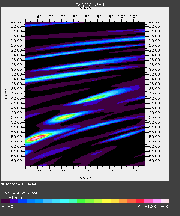
| Estimated Moho Depth: |
58.25 km |
| Estimated Crust Vp/Vs: |
1.64 |
| Assumed Crust Vp: |
6.306 km/s |
| Estimated Crust Vs: |
3.833 km/s |
| Estimated Crust Poisson's Ratio: |
0.21 |
|
| Radial Match: |
93.34442 % |
| Radial Bump: |
400 |
| Transverse Match: |
83.70478 % |
| Transverse Bump: |
400 |
| SOD ConfigId: |
2504 |
| Insert Time: |
2010-03-06 07:14:01.420 +0000 |
| GWidth: |
2.5 |
| Max Bumps: |
400 |
| Tol: |
0.001 |
|

Signal To Noise
| Channel | StoN | STA | LTA |
| TA:Q21A: :BHN:20080502T01:41:52.42399Z | 15.0708 | 1.3283461E-6 | 8.814039E-8 |
| TA:Q21A: :BHE:20080502T01:41:52.42399Z | 6.1048007 | 4.811299E-7 | 7.881174E-8 |
| TA:Q21A: :BHZ:20080502T01:41:52.42399Z | 5.510661 | 5.182634E-7 | 9.404741E-8 |
| Arrivals |
| Ps | 6.3 SECOND |
| PpPs | 23 SECOND |
| PsPs/PpSs | 29 SECOND |


