You are here: Home > Network List > TA - USArray Transportable Network (new EarthScope stations) Stations List
> Station Q21A Lamborn Mesa, Paonia, CO, USA > Earthquake Result Viewer
Q21A Lamborn Mesa, Paonia, CO, USA - Earthquake Result Viewer
| Earthquake location: |
Hokkaido, Japan Region |
| Earthquake latitude/longitude: |
41.5/139.0 |
| Earthquake time(UTC): |
2008/06/04 (156) 17:03:07 GMT |
| Earthquake Depth: |
213 km |
| Earthquake Magnitude: |
5.5 MB, 5.7 MW, 5.7 MW |
| Earthquake Catalog/Contributor: |
WHDF/NEIC |
|
| Network: |
TA USArray Transportable Network (new EarthScope stations) |
| Station: |
Q21A Lamborn Mesa, Paonia, CO, USA |
| Lat/Lon: |
38.83 N/107.57 W |
| Elevation: |
1881 m |
|
| Distance: |
79.6 deg |
| Az: |
46.784 deg |
| Baz: |
315.528 deg |
| Ray Param: |
0.048288934 |
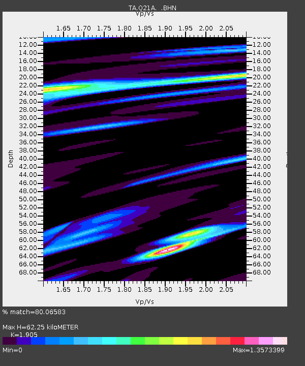
| Estimated Moho Depth: |
62.25 km |
| Estimated Crust Vp/Vs: |
1.90 |
| Assumed Crust Vp: |
6.306 km/s |
| Estimated Crust Vs: |
3.31 km/s |
| Estimated Crust Poisson's Ratio: |
0.31 |
|
| Radial Match: |
80.06583 % |
| Radial Bump: |
400 |
| Transverse Match: |
63.42567 % |
| Transverse Bump: |
400 |
| SOD ConfigId: |
2504 |
| Insert Time: |
2010-03-06 07:14:08.420 +0000 |
| GWidth: |
2.5 |
| Max Bumps: |
400 |
| Tol: |
0.001 |
|
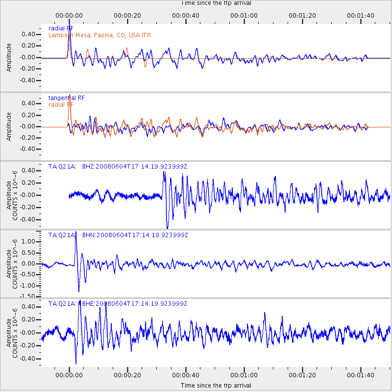
Signal To Noise
| Channel | StoN | STA | LTA |
| TA:Q21A: :BHN:20080604T17:14:19.923999Z | 8.879396 | 5.4724404E-7 | 6.163077E-8 |
| TA:Q21A: :BHE:20080604T17:14:19.923999Z | 4.91608 | 2.291008E-7 | 4.6602334E-8 |
| TA:Q21A: :BHZ:20080604T17:14:19.923999Z | 5.6637683 | 2.3427036E-7 | 4.1362984E-8 |
| Arrivals |
| Ps | 9.2 SECOND |
| PpPs | 28 SECOND |
| PsPs/PpSs | 37 SECOND |


