You are here: Home > Network List > NR - NARS Array Stations List
> Station NE206 Kasane > Earthquake Result Viewer
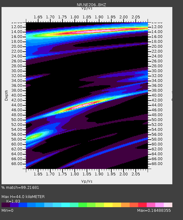
NE206 Kasane - Earthquake Result Viewer
| Earthquake location: |
Eastern Kashmir |
| Earthquake latitude/longitude: |
35.7/77.6 |
| Earthquake time(UTC): |
2017/12/06 (340) 23:29:02 GMT |
| Earthquake Depth: |
59 km |
| Earthquake Magnitude: |
5.1 Mww |
| Earthquake Catalog/Contributor: |
NEIC PDE/us |
|
| Network: |
NR NARS Array |
| Station: |
NE206 Kasane |
| Lat/Lon: |
17.80 S/25.16 E |
| Elevation: |
1006 m |
|
| Distance: |
72.7 deg |
| Az: |
232.23 deg |
| Baz: |
42.498 deg |
| Ray Param: |
0.053348877 |
| Estimated Moho Depth: |
44.0 km |
| Estimated Crust Vp/Vs: |
1.83 |
| Assumed Crust Vp: |
6.612 km/s |
| Estimated Crust Vs: |
3.613 km/s |
| Estimated Crust Poisson's Ratio: |
0.29 |
|
| Radial Match: |
99.21681 % |
| Radial Bump: |
89 |
| Transverse Match: |
87.305214 % |
| Transverse Bump: |
400 |
| SOD ConfigId: |
13570011 |
| Insert Time: |
2019-04-29 09:15:02.080 +0000 |
| GWidth: |
2.5 |
| Max Bumps: |
400 |
| Tol: |
0.001 |
|

Signal To Noise
| Channel | StoN | STA | LTA |
| NR:NE206: :BHZ:20171206T23:39:52.971978Z | 4.5651717 | 2.541492E-6 | 5.5671336E-7 |
| NR:NE206: :BHN:20171206T23:39:52.971978Z | 4.873972 | 2.9518346E-6 | 6.0563224E-7 |
| NR:NE206: :BHE:20171206T23:39:52.971978Z | 4.360845 | 1.81187E-6 | 4.1548597E-7 |
| Arrivals |
| Ps | 5.7 SECOND |
| PpPs | 18 SECOND |
| PsPs/PpSs | 24 SECOND |


