You are here: Home > Network List > TA - USArray Transportable Network (new EarthScope stations) Stations List
> Station Q21A Lamborn Mesa, Paonia, CO, USA > Earthquake Result Viewer
Q21A Lamborn Mesa, Paonia, CO, USA - Earthquake Result Viewer
| Earthquake location: |
Off East Coast Of Honshu, Japan |
| Earthquake latitude/longitude: |
37.6/142.2 |
| Earthquake time(UTC): |
2008/07/19 (201) 02:39:28 GMT |
| Earthquake Depth: |
22 km |
| Earthquake Magnitude: |
6.2 MB, 7.0 MS, 7.0 MW, 6.9 MW |
| Earthquake Catalog/Contributor: |
WHDF/NEIC |
|
| Network: |
TA USArray Transportable Network (new EarthScope stations) |
| Station: |
Q21A Lamborn Mesa, Paonia, CO, USA |
| Lat/Lon: |
38.83 N/107.57 W |
| Elevation: |
1881 m |
|
| Distance: |
80.5 deg |
| Az: |
47.992 deg |
| Baz: |
310.875 deg |
| Ray Param: |
0.048192818 |
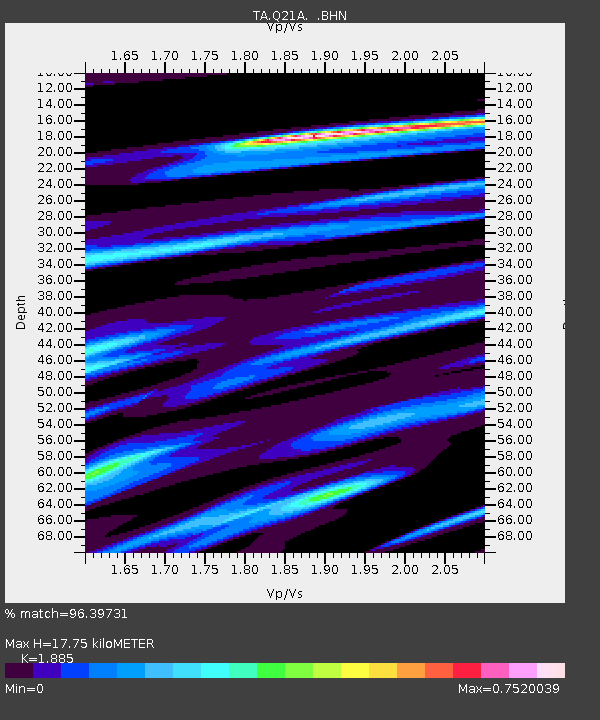
| Estimated Moho Depth: |
17.75 km |
| Estimated Crust Vp/Vs: |
1.88 |
| Assumed Crust Vp: |
6.306 km/s |
| Estimated Crust Vs: |
3.345 km/s |
| Estimated Crust Poisson's Ratio: |
0.30 |
|
| Radial Match: |
96.39731 % |
| Radial Bump: |
349 |
| Transverse Match: |
88.015175 % |
| Transverse Bump: |
400 |
| SOD ConfigId: |
2504 |
| Insert Time: |
2010-03-06 07:14:16.530 +0000 |
| GWidth: |
2.5 |
| Max Bumps: |
400 |
| Tol: |
0.001 |
|
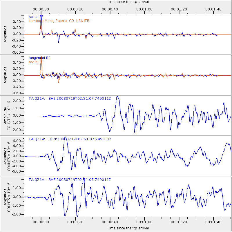
Signal To Noise
| Channel | StoN | STA | LTA |
| TA:Q21A: :BHN:20080719T02:51:07.749011Z | 6.269204 | 5.2814676E-7 | 8.424463E-8 |
| TA:Q21A: :BHE:20080719T02:51:07.749011Z | 2.914664 | 1.4021168E-7 | 4.8105605E-8 |
| TA:Q21A: :BHZ:20080719T02:51:07.749011Z | 3.447804 | 2.0258013E-7 | 5.875628E-8 |
| Arrivals |
| Ps | 2.6 SECOND |
| PpPs | 7.9 SECOND |
| PsPs/PpSs | 10 SECOND |


