You are here: Home > Network List > TA - USArray Transportable Network (new EarthScope stations) Stations List
> Station F21K Alatna River, AK, USA > Earthquake Result Viewer
F21K Alatna River, AK, USA - Earthquake Result Viewer
*The percent match for this event was below the threshold and hence no stack was calculated.
| Earthquake location: |
Eastern Kashmir |
| Earthquake latitude/longitude: |
35.7/77.6 |
| Earthquake time(UTC): |
2017/12/06 (340) 23:29:02 GMT |
| Earthquake Depth: |
59 km |
| Earthquake Magnitude: |
5.1 Mww |
| Earthquake Catalog/Contributor: |
NEIC PDE/us |
|
| Network: |
TA USArray Transportable Network (new EarthScope stations) |
| Station: |
F21K Alatna River, AK, USA |
| Lat/Lon: |
67.22 N/153.48 W |
| Elevation: |
597 m |
|
| Distance: |
70.4 deg |
| Az: |
18.748 deg |
| Baz: |
317.77 deg |
| Ray Param: |
$rayparam |
*The percent match for this event was below the threshold and hence was not used in the summary stack. |
|
| Radial Match: |
50.252087 % |
| Radial Bump: |
400 |
| Transverse Match: |
42.128685 % |
| Transverse Bump: |
400 |
| SOD ConfigId: |
13570011 |
| Insert Time: |
2019-04-29 09:15:51.820 +0000 |
| GWidth: |
2.5 |
| Max Bumps: |
400 |
| Tol: |
0.001 |
|
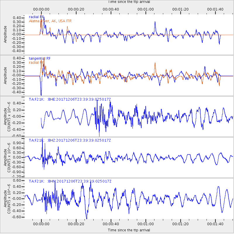
Signal To Noise
| Channel | StoN | STA | LTA |
| TA:F21K: :BHZ:20171206T23:39:39.025017Z | 3.6305356 | 3.4308297E-7 | 9.449928E-8 |
| TA:F21K: :BHN:20171206T23:39:39.025017Z | 0.83503735 | 1.5505283E-7 | 1.856837E-7 |
| TA:F21K: :BHE:20171206T23:39:39.025017Z | 1.7364477 | 2.396667E-7 | 1.3802125E-7 |
| Arrivals |
| Ps | |
| PpPs | |
| PsPs/PpSs | |


