You are here: Home > Network List > TA - USArray Transportable Network (new EarthScope stations) Stations List
> Station G22K Bettles, AK, USA > Earthquake Result Viewer
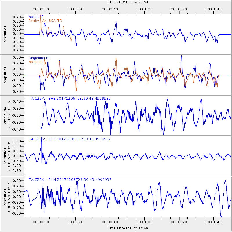
G22K Bettles, AK, USA - Earthquake Result Viewer
*The percent match for this event was below the threshold and hence no stack was calculated.
| Earthquake location: |
Eastern Kashmir |
| Earthquake latitude/longitude: |
35.7/77.6 |
| Earthquake time(UTC): |
2017/12/06 (340) 23:29:02 GMT |
| Earthquake Depth: |
59 km |
| Earthquake Magnitude: |
5.1 Mww |
| Earthquake Catalog/Contributor: |
NEIC PDE/us |
|
| Network: |
TA USArray Transportable Network (new EarthScope stations) |
| Station: |
G22K Bettles, AK, USA |
| Lat/Lon: |
66.92 N/151.51 W |
| Elevation: |
205 m |
|
| Distance: |
71.1 deg |
| Az: |
18.345 deg |
| Baz: |
319.455 deg |
| Ray Param: |
$rayparam |
*The percent match for this event was below the threshold and hence was not used in the summary stack. |
|
| Radial Match: |
65.183975 % |
| Radial Bump: |
400 |
| Transverse Match: |
57.99895 % |
| Transverse Bump: |
400 |
| SOD ConfigId: |
13570011 |
| Insert Time: |
2019-04-29 09:15:54.451 +0000 |
| GWidth: |
2.5 |
| Max Bumps: |
400 |
| Tol: |
0.001 |
|
Signal To Noise
| Channel | StoN | STA | LTA |
| TA:G22K: :BHZ:20171206T23:39:43.499993Z | 3.5463028 | 5.450048E-7 | 1.5368255E-7 |
| TA:G22K: :BHN:20171206T23:39:43.499993Z | 0.7209008 | 2.2843832E-7 | 3.16879E-7 |
| TA:G22K: :BHE:20171206T23:39:43.499993Z | 0.9723557 | 1.6632553E-7 | 1.7105421E-7 |
| Arrivals |
| Ps | |
| PpPs | |
| PsPs/PpSs | |


