You are here: Home > Network List > TA - USArray Transportable Network (new EarthScope stations) Stations List
> Station O18K Koktuh Hills, AK, USA > Earthquake Result Viewer
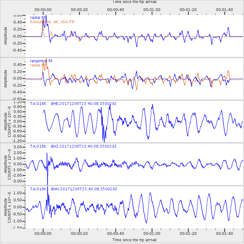
O18K Koktuh Hills, AK, USA - Earthquake Result Viewer
*The percent match for this event was below the threshold and hence no stack was calculated.
| Earthquake location: |
Eastern Kashmir |
| Earthquake latitude/longitude: |
35.7/77.6 |
| Earthquake time(UTC): |
2017/12/06 (340) 23:29:02 GMT |
| Earthquake Depth: |
59 km |
| Earthquake Magnitude: |
5.1 Mww |
| Earthquake Catalog/Contributor: |
NEIC PDE/us |
|
| Network: |
TA USArray Transportable Network (new EarthScope stations) |
| Station: |
O18K Koktuh Hills, AK, USA |
| Lat/Lon: |
59.85 N/155.21 W |
| Elevation: |
544 m |
|
| Distance: |
75.4 deg |
| Az: |
24.54 deg |
| Baz: |
317.932 deg |
| Ray Param: |
$rayparam |
*The percent match for this event was below the threshold and hence was not used in the summary stack. |
|
| Radial Match: |
65.7087 % |
| Radial Bump: |
400 |
| Transverse Match: |
59.765785 % |
| Transverse Bump: |
400 |
| SOD ConfigId: |
13570011 |
| Insert Time: |
2019-04-29 09:16:12.842 +0000 |
| GWidth: |
2.5 |
| Max Bumps: |
400 |
| Tol: |
0.001 |
|
Signal To Noise
| Channel | StoN | STA | LTA |
| TA:O18K: :BHZ:20171206T23:40:08.350029Z | 2.5698843 | 9.458607E-7 | 3.6805577E-7 |
| TA:O18K: :BHN:20171206T23:40:08.350029Z | 2.0765572 | 5.524433E-7 | 2.6603809E-7 |
| TA:O18K: :BHE:20171206T23:40:08.350029Z | 1.4320575 | 6.607953E-7 | 4.614307E-7 |
| Arrivals |
| Ps | |
| PpPs | |
| PsPs/PpSs | |


