You are here: Home > Network List > TA - USArray Transportable Network (new EarthScope stations) Stations List
> Station Q21A Lamborn Mesa, Paonia, CO, USA > Earthquake Result Viewer
Q21A Lamborn Mesa, Paonia, CO, USA - Earthquake Result Viewer
| Earthquake location: |
Lake Baykal Region, Russia |
| Earthquake latitude/longitude: |
51.6/104.2 |
| Earthquake time(UTC): |
2008/08/27 (240) 01:35:32 GMT |
| Earthquake Depth: |
16 km |
| Earthquake Magnitude: |
5.8 MB, 6.2 MS, 6.2 MW, 6.2 MW |
| Earthquake Catalog/Contributor: |
WHDF/NEIC |
|
| Network: |
TA USArray Transportable Network (new EarthScope stations) |
| Station: |
Q21A Lamborn Mesa, Paonia, CO, USA |
| Lat/Lon: |
38.83 N/107.57 W |
| Elevation: |
1881 m |
|
| Distance: |
85.8 deg |
| Az: |
24.324 deg |
| Baz: |
340.799 deg |
| Ray Param: |
0.044524204 |
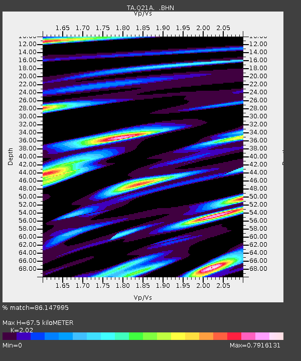
| Estimated Moho Depth: |
67.5 km |
| Estimated Crust Vp/Vs: |
2.02 |
| Assumed Crust Vp: |
6.306 km/s |
| Estimated Crust Vs: |
3.122 km/s |
| Estimated Crust Poisson's Ratio: |
0.34 |
|
| Radial Match: |
86.147995 % |
| Radial Bump: |
400 |
| Transverse Match: |
77.60688 % |
| Transverse Bump: |
400 |
| SOD ConfigId: |
2504 |
| Insert Time: |
2010-03-06 07:14:37.615 +0000 |
| GWidth: |
2.5 |
| Max Bumps: |
400 |
| Tol: |
0.001 |
|

Signal To Noise
| Channel | StoN | STA | LTA |
| TA:Q21A: :BHN:20080827T01:47:38.949011Z | 6.6006045 | 3.9966713E-7 | 6.055008E-8 |
| TA:Q21A: :BHE:20080827T01:47:38.949011Z | 2.8472419 | 1.901185E-7 | 6.677286E-8 |
| TA:Q21A: :BHZ:20080827T01:47:38.949011Z | 2.5263026 | 1.2434892E-7 | 4.9221704E-8 |
| Arrivals |
| Ps | 11 SECOND |
| PpPs | 32 SECOND |
| PsPs/PpSs | 43 SECOND |


