You are here: Home > Network List > AK - Alaska Regional Network Stations List
> Station FYU Fort Yukon, Alaska, USA > Earthquake Result Viewer
FYU Fort Yukon, Alaska, USA - Earthquake Result Viewer
| Earthquake location: |
W. Caroline Islands, Micronesia |
| Earthquake latitude/longitude: |
10.1/140.2 |
| Earthquake time(UTC): |
2017/12/08 (342) 00:22:53 GMT |
| Earthquake Depth: |
7.5 km |
| Earthquake Magnitude: |
6.5 mww |
| Earthquake Catalog/Contributor: |
NEIC PDE/us |
|
| Network: |
AK Alaska Regional Network |
| Station: |
FYU Fort Yukon, Alaska, USA |
| Lat/Lon: |
66.57 N/145.23 W |
| Elevation: |
137 m |
|
| Distance: |
74.6 deg |
| Az: |
23.568 deg |
| Baz: |
259.833 deg |
| Ray Param: |
0.05221591 |
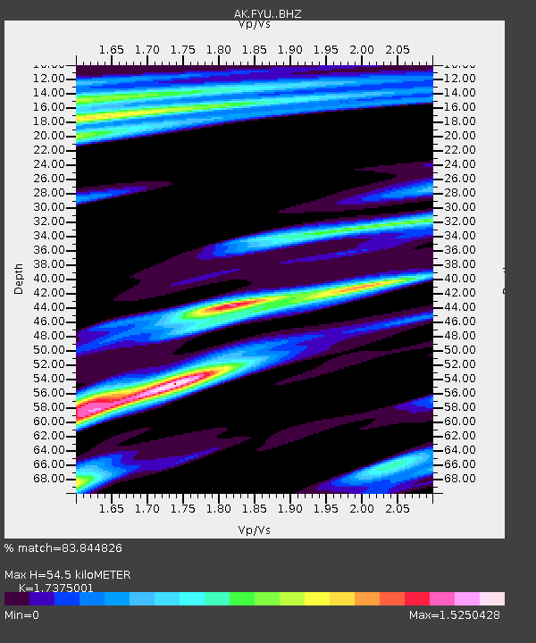
| Estimated Moho Depth: |
54.5 km |
| Estimated Crust Vp/Vs: |
1.74 |
| Assumed Crust Vp: |
6.522 km/s |
| Estimated Crust Vs: |
3.753 km/s |
| Estimated Crust Poisson's Ratio: |
0.25 |
|
| Radial Match: |
83.844826 % |
| Radial Bump: |
333 |
| Transverse Match: |
80.77873 % |
| Transverse Bump: |
368 |
| SOD ConfigId: |
13570011 |
| Insert Time: |
2019-04-29 09:17:14.401 +0000 |
| GWidth: |
2.5 |
| Max Bumps: |
400 |
| Tol: |
0.001 |
|

Signal To Noise
| Channel | StoN | STA | LTA |
| AK:FYU: :BHZ:20171208T00:34:01.80802Z | 3.837556 | 9.697369E-7 | 2.526965E-7 |
| AK:FYU: :BHN:20171208T00:34:01.80802Z | 1.1344286 | 1.0706588E-6 | 9.437868E-7 |
| AK:FYU: :BHE:20171208T00:34:01.80802Z | 0.3281464 | 5.150986E-7 | 1.5697219E-6 |
| Arrivals |
| Ps | 6.4 SECOND |
| PpPs | 22 SECOND |
| PsPs/PpSs | 28 SECOND |


