You are here: Home > Network List > AU - Australian Seismological Centre Stations List
> Station NWAO Narrogin, Western Australia > Earthquake Result Viewer
NWAO Narrogin, Western Australia - Earthquake Result Viewer
| Earthquake location: |
W. Caroline Islands, Micronesia |
| Earthquake latitude/longitude: |
10.1/140.2 |
| Earthquake time(UTC): |
2017/12/08 (342) 00:22:53 GMT |
| Earthquake Depth: |
7.5 km |
| Earthquake Magnitude: |
6.5 mww |
| Earthquake Catalog/Contributor: |
NEIC PDE/us |
|
| Network: |
AU Australian Seismological Centre |
| Station: |
NWAO Narrogin, Western Australia |
| Lat/Lon: |
32.93 S/117.24 E |
| Elevation: |
265 m |
|
| Distance: |
48.1 deg |
| Az: |
206.156 deg |
| Baz: |
31.069 deg |
| Ray Param: |
0.06957476 |
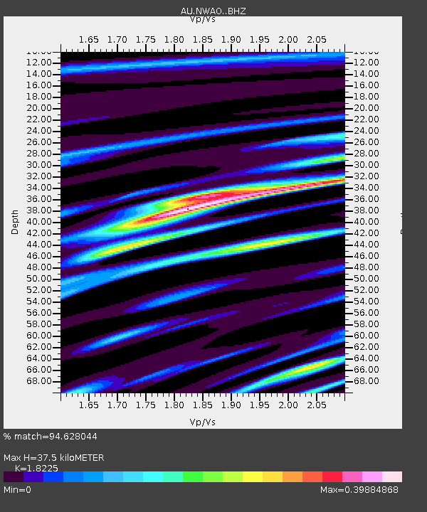
| Estimated Moho Depth: |
37.5 km |
| Estimated Crust Vp/Vs: |
1.82 |
| Assumed Crust Vp: |
6.419 km/s |
| Estimated Crust Vs: |
3.522 km/s |
| Estimated Crust Poisson's Ratio: |
0.28 |
|
| Radial Match: |
94.628044 % |
| Radial Bump: |
240 |
| Transverse Match: |
66.909904 % |
| Transverse Bump: |
400 |
| SOD ConfigId: |
13570011 |
| Insert Time: |
2019-04-29 09:17:55.147 +0000 |
| GWidth: |
2.5 |
| Max Bumps: |
400 |
| Tol: |
0.001 |
|

Signal To Noise
| Channel | StoN | STA | LTA |
| AU:NWAO: :BHZ:20171208T00:31:02.525Z | 27.23939 | 2.503365E-5 | 9.190239E-7 |
| AU:NWAO: :BH1:20171208T00:31:02.525Z | 3.9685347 | 8.129282E-6 | 2.048434E-6 |
| AU:NWAO: :BH2:20171208T00:31:02.525Z | 21.379162 | 1.30196295E-5 | 6.089869E-7 |
| Arrivals |
| Ps | 5.1 SECOND |
| PpPs | 16 SECOND |
| PsPs/PpSs | 21 SECOND |


