You are here: Home > Network List > S - Seismographs in Schools Projects Stations List
> Station AUBSH Beerwah State High School, QLD > Earthquake Result Viewer
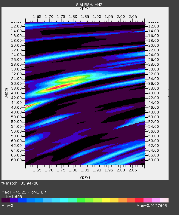
AUBSH Beerwah State High School, QLD - Earthquake Result Viewer
| Earthquake location: |
W. Caroline Islands, Micronesia |
| Earthquake latitude/longitude: |
10.1/140.2 |
| Earthquake time(UTC): |
2017/12/08 (342) 00:22:53 GMT |
| Earthquake Depth: |
7.5 km |
| Earthquake Magnitude: |
6.5 mww |
| Earthquake Catalog/Contributor: |
NEIC PDE/us |
|
| Network: |
S Seismographs in Schools Projects |
| Station: |
AUBSH Beerwah State High School, QLD |
| Lat/Lon: |
26.86 S/152.95 E |
| Elevation: |
26 m |
|
| Distance: |
38.8 deg |
| Az: |
161.669 deg |
| Baz: |
339.718 deg |
| Ray Param: |
0.07535005 |
| Estimated Moho Depth: |
45.25 km |
| Estimated Crust Vp/Vs: |
1.61 |
| Assumed Crust Vp: |
6.472 km/s |
| Estimated Crust Vs: |
4.032 km/s |
| Estimated Crust Poisson's Ratio: |
0.18 |
|
| Radial Match: |
83.94708 % |
| Radial Bump: |
257 |
| Transverse Match: |
71.51436 % |
| Transverse Bump: |
400 |
| SOD ConfigId: |
13570011 |
| Insert Time: |
2019-04-29 09:20:40.202 +0000 |
| GWidth: |
2.5 |
| Max Bumps: |
400 |
| Tol: |
0.001 |
|

Signal To Noise
| Channel | StoN | STA | LTA |
| S:AUBSH: :HHZ:20171208T00:29:47.590002Z | 17.973791 | 3.5627238E-6 | 1.9821772E-7 |
| S:AUBSH: :HHN:20171208T00:29:47.590002Z | 6.8555293 | 1.6839399E-6 | 2.4563238E-7 |
| S:AUBSH: :HHE:20171208T00:29:47.590002Z | 3.8321629 | 1.5967005E-6 | 4.1665777E-7 |
| Arrivals |
| Ps | 4.6 SECOND |
| PpPs | 17 SECOND |
| PsPs/PpSs | 21 SECOND |


