You are here: Home > Network List > S - Seismographs in Schools Projects Stations List
> Station AUCAS Cummins Area School, SA > Earthquake Result Viewer
AUCAS Cummins Area School, SA - Earthquake Result Viewer
| Earthquake location: |
W. Caroline Islands, Micronesia |
| Earthquake latitude/longitude: |
10.1/140.2 |
| Earthquake time(UTC): |
2017/12/08 (342) 00:22:53 GMT |
| Earthquake Depth: |
7.5 km |
| Earthquake Magnitude: |
6.5 mww |
| Earthquake Catalog/Contributor: |
NEIC PDE/us |
|
| Network: |
S Seismographs in Schools Projects |
| Station: |
AUCAS Cummins Area School, SA |
| Lat/Lon: |
34.26 S/135.72 E |
| Elevation: |
72 m |
|
| Distance: |
44.4 deg |
| Az: |
185.312 deg |
| Baz: |
6.319 deg |
| Ray Param: |
0.07196543 |
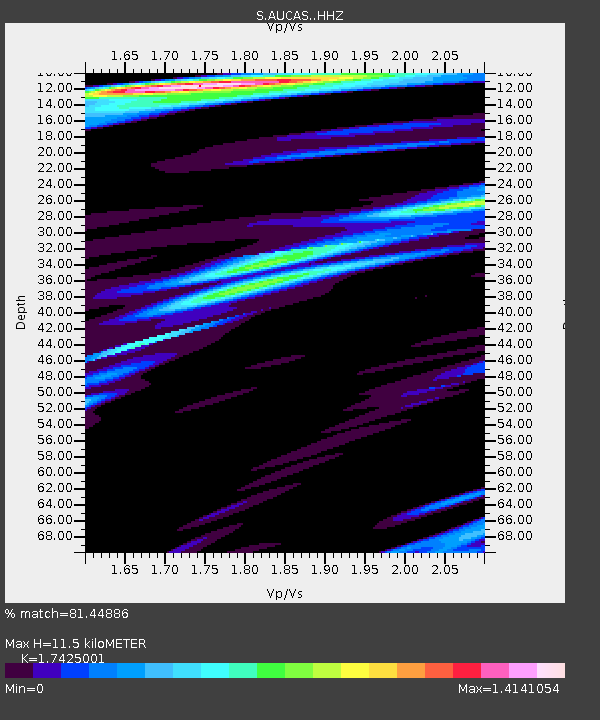
| Estimated Moho Depth: |
11.5 km |
| Estimated Crust Vp/Vs: |
1.74 |
| Assumed Crust Vp: |
6.134 km/s |
| Estimated Crust Vs: |
3.52 km/s |
| Estimated Crust Poisson's Ratio: |
0.25 |
|
| Radial Match: |
81.44886 % |
| Radial Bump: |
400 |
| Transverse Match: |
52.562016 % |
| Transverse Bump: |
400 |
| SOD ConfigId: |
13570011 |
| Insert Time: |
2019-04-29 09:20:41.822 +0000 |
| GWidth: |
2.5 |
| Max Bumps: |
400 |
| Tol: |
0.001 |
|

Signal To Noise
| Channel | StoN | STA | LTA |
| S:AUCAS: :HHZ:20171208T00:30:33.070013Z | 9.15055 | 7.071361E-6 | 7.727799E-7 |
| S:AUCAS: :HHN:20171208T00:30:33.070013Z | 6.5716987 | 4.984693E-6 | 7.585091E-7 |
| S:AUCAS: :HHE:20171208T00:30:33.070013Z | 1.2666037 | 1.1958259E-6 | 9.4411996E-7 |
| Arrivals |
| Ps | 1.5 SECOND |
| PpPs | 4.8 SECOND |
| PsPs/PpSs | 6.3 SECOND |


