You are here: Home > Network List > TA - USArray Transportable Network (new EarthScope stations) Stations List
> Station D24K Happy Valley, AK, USA > Earthquake Result Viewer
D24K Happy Valley, AK, USA - Earthquake Result Viewer
| Earthquake location: |
W. Caroline Islands, Micronesia |
| Earthquake latitude/longitude: |
10.1/140.2 |
| Earthquake time(UTC): |
2017/12/08 (342) 00:22:53 GMT |
| Earthquake Depth: |
7.5 km |
| Earthquake Magnitude: |
6.5 mww |
| Earthquake Catalog/Contributor: |
NEIC PDE/us |
|
| Network: |
TA USArray Transportable Network (new EarthScope stations) |
| Station: |
D24K Happy Valley, AK, USA |
| Lat/Lon: |
69.15 N/148.82 W |
| Elevation: |
292 m |
|
| Distance: |
73.8 deg |
| Az: |
20.629 deg |
| Baz: |
255.709 deg |
| Ray Param: |
0.052740548 |
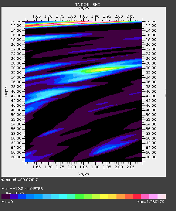
| Estimated Moho Depth: |
10.5 km |
| Estimated Crust Vp/Vs: |
1.82 |
| Assumed Crust Vp: |
6.316 km/s |
| Estimated Crust Vs: |
3.466 km/s |
| Estimated Crust Poisson's Ratio: |
0.28 |
|
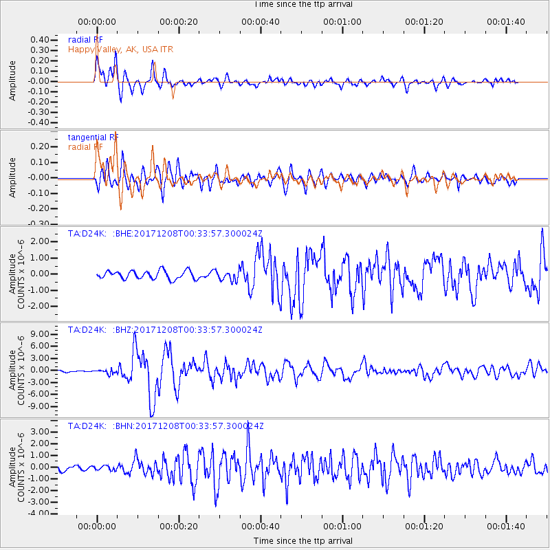
| Radial Match: |
89.87417 % |
| Radial Bump: |
400 |
| Transverse Match: |
89.078926 % |
| Transverse Bump: |
400 |
| SOD ConfigId: |
13570011 |
| Insert Time: |
2019-04-29 09:21:03.325 +0000 |
| GWidth: |
2.5 |
| Max Bumps: |
400 |
| Tol: |
0.001 |
|
Signal To Noise
| Channel | StoN | STA | LTA |
| TA:D24K: :BHZ:20171208T00:33:57.300024Z | 3.483922 | 4.9893754E-7 | 1.4321145E-7 |
| TA:D24K: :BHN:20171208T00:33:57.300024Z | 0.97114563 | 1.767871E-7 | 1.8203973E-7 |
| TA:D24K: :BHE:20171208T00:33:57.300024Z | 1.193164 | 3.0280614E-7 | 2.5378418E-7 |
| Arrivals |
| Ps | 1.4 SECOND |
| PpPs | 4.5 SECOND |
| PsPs/PpSs | 6.0 SECOND |


