You are here: Home > Network List > TA - USArray Transportable Network (new EarthScope stations) Stations List
> Station E18K Tukpahlearik Creek, AK, USA > Earthquake Result Viewer
E18K Tukpahlearik Creek, AK, USA - Earthquake Result Viewer
| Earthquake location: |
W. Caroline Islands, Micronesia |
| Earthquake latitude/longitude: |
10.1/140.2 |
| Earthquake time(UTC): |
2017/12/08 (342) 00:22:53 GMT |
| Earthquake Depth: |
7.5 km |
| Earthquake Magnitude: |
6.5 mww |
| Earthquake Catalog/Contributor: |
NEIC PDE/us |
|
| Network: |
TA USArray Transportable Network (new EarthScope stations) |
| Station: |
E18K Tukpahlearik Creek, AK, USA |
| Lat/Lon: |
67.42 N/160.60 W |
| Elevation: |
297 m |
|
| Distance: |
69.1 deg |
| Az: |
20.79 deg |
| Baz: |
244.82 deg |
| Ray Param: |
0.055852544 |
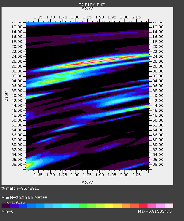
| Estimated Moho Depth: |
25.25 km |
| Estimated Crust Vp/Vs: |
1.91 |
| Assumed Crust Vp: |
6.276 km/s |
| Estimated Crust Vs: |
3.281 km/s |
| Estimated Crust Poisson's Ratio: |
0.31 |
|
| Radial Match: |
95.48911 % |
| Radial Bump: |
305 |
| Transverse Match: |
89.01444 % |
| Transverse Bump: |
400 |
| SOD ConfigId: |
13570011 |
| Insert Time: |
2019-04-29 09:21:04.461 +0000 |
| GWidth: |
2.5 |
| Max Bumps: |
400 |
| Tol: |
0.001 |
|

Signal To Noise
| Channel | StoN | STA | LTA |
| TA:E18K: :BHZ:20171208T00:33:28.999976Z | 2.3202987 | 3.8397422E-7 | 1.6548483E-7 |
| TA:E18K: :BHN:20171208T00:33:28.999976Z | 1.5697767 | 2.5906678E-7 | 1.6503417E-7 |
| TA:E18K: :BHE:20171208T00:33:28.999976Z | 1.8807006 | 2.0870121E-7 | 1.1096993E-7 |
| Arrivals |
| Ps | 3.8 SECOND |
| PpPs | 11 SECOND |
| PsPs/PpSs | 15 SECOND |


