You are here: Home > Network List > TA - USArray Transportable Network (new EarthScope stations) Stations List
> Station E20K Nigu River, AK, USA > Earthquake Result Viewer
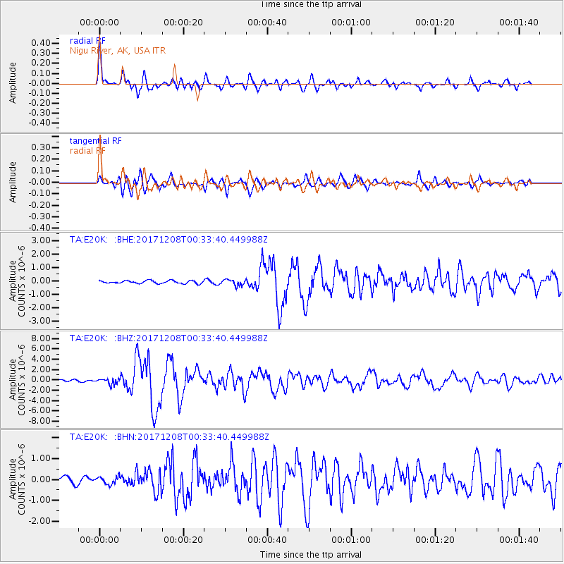
E20K Nigu River, AK, USA - Earthquake Result Viewer

| Earthquake location: |
W. Caroline Islands, Micronesia |
| Earthquake latitude/longitude: |
10.1/140.2 |
| Earthquake time(UTC): |
2017/12/08 (342) 00:22:53 GMT |
| Earthquake Depth: |
7.5 km |
| Earthquake Magnitude: |
6.5 mww |
| Earthquake Catalog/Contributor: |
NEIC PDE/us |
|
| Network: |
TA USArray Transportable Network (new EarthScope stations) |
| Station: |
E20K Nigu River, AK, USA |
| Lat/Lon: |
68.26 N/156.19 W |
| Elevation: |
866 m |
|
| Distance: |
71.0 deg |
| Az: |
20.669 deg |
| Baz: |
248.864 deg |
| Ray Param: |
0.054611936 |
| Estimated Moho Depth: |
65.5 km |
| Estimated Crust Vp/Vs: |
1.99 |
| Assumed Crust Vp: |
6.221 km/s |
| Estimated Crust Vs: |
3.122 km/s |
| Estimated Crust Poisson's Ratio: |
0.33 |
|
| Radial Match: |
91.981735 % |
| Radial Bump: |
400 |
| Transverse Match: |
85.59035 % |
| Transverse Bump: |
400 |
| SOD ConfigId: |
13570011 |
| Insert Time: |
2019-04-29 09:21:05.443 +0000 |
| GWidth: |
2.5 |
| Max Bumps: |
400 |
| Tol: |
0.001 |
|
Signal To Noise
| Channel | StoN | STA | LTA |
| TA:E20K: :BHZ:20171208T00:33:40.449988Z | 2.4592316 | 5.583534E-7 | 2.2704384E-7 |
| TA:E20K: :BHN:20171208T00:33:40.449988Z | 0.84018904 | 1.7970947E-7 | 2.1389172E-7 |
| TA:E20K: :BHE:20171208T00:33:40.449988Z | 1.9977583 | 2.1444846E-7 | 1.07344555E-7 |
| Arrivals |
| Ps | 11 SECOND |
| PpPs | 31 SECOND |
| PsPs/PpSs | 41 SECOND |


