You are here: Home > Network List > TA - USArray Transportable Network (new EarthScope stations) Stations List
> Station Q21A Lamborn Mesa, Paonia, CO, USA > Earthquake Result Viewer
Q21A Lamborn Mesa, Paonia, CO, USA - Earthquake Result Viewer
| Earthquake location: |
Santa Cruz Islands |
| Earthquake latitude/longitude: |
-12.4/166.1 |
| Earthquake time(UTC): |
2009/10/07 (280) 22:50:15 GMT |
| Earthquake Depth: |
21 km |
| Earthquake Magnitude: |
5.8 MB |
| Earthquake Catalog/Contributor: |
WHDF/NEIC |
|
| Network: |
TA USArray Transportable Network (new EarthScope stations) |
| Station: |
Q21A Lamborn Mesa, Paonia, CO, USA |
| Lat/Lon: |
38.83 N/107.57 W |
| Elevation: |
1881 m |
|
| Distance: |
94.8 deg |
| Az: |
51.463 deg |
| Baz: |
258.101 deg |
| Ray Param: |
0.04093366 |
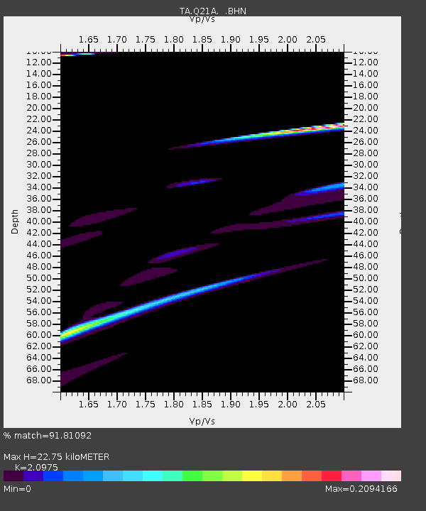
| Estimated Moho Depth: |
22.75 km |
| Estimated Crust Vp/Vs: |
2.10 |
| Assumed Crust Vp: |
6.306 km/s |
| Estimated Crust Vs: |
3.006 km/s |
| Estimated Crust Poisson's Ratio: |
0.35 |
|
| Radial Match: |
91.81092 % |
| Radial Bump: |
316 |
| Transverse Match: |
47.79163 % |
| Transverse Bump: |
179 |
| SOD ConfigId: |
2622 |
| Insert Time: |
2010-03-06 07:15:39.869 +0000 |
| GWidth: |
2.5 |
| Max Bumps: |
400 |
| Tol: |
0.001 |
|
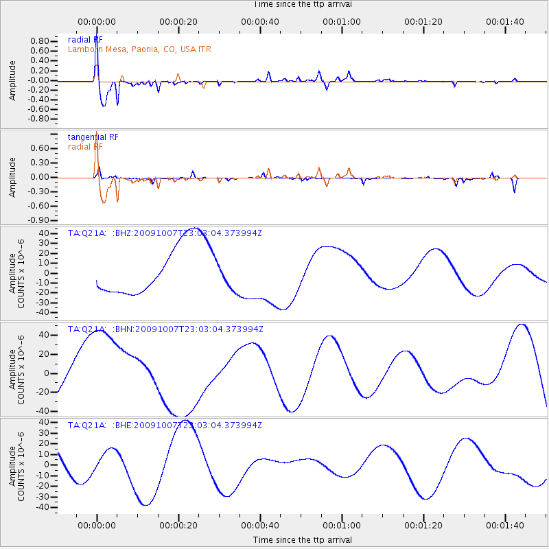
Signal To Noise
| Channel | StoN | STA | LTA |
| TA:Q21A: :BHN:20091007T23:03:04.373994Z | 3.1569667 | 5.5222023E-5 | 1.7492113E-5 |
| TA:Q21A: :BHE:20091007T23:03:04.373994Z | 1.0133171 | 1.0524187E-5 | 1.0385877E-5 |
| TA:Q21A: :BHZ:20091007T23:03:04.373994Z | 0.5834069 | 1.4380694E-5 | 2.4649507E-5 |
| Arrivals |
| Ps | 4.0 SECOND |
| PpPs | 11 SECOND |
| PsPs/PpSs | 15 SECOND |


