You are here: Home > Network List > TA - USArray Transportable Network (new EarthScope stations) Stations List
> Station I17K Unalakleet, AK, USA > Earthquake Result Viewer
I17K Unalakleet, AK, USA - Earthquake Result Viewer
| Earthquake location: |
W. Caroline Islands, Micronesia |
| Earthquake latitude/longitude: |
10.1/140.2 |
| Earthquake time(UTC): |
2017/12/08 (342) 00:22:53 GMT |
| Earthquake Depth: |
7.5 km |
| Earthquake Magnitude: |
6.5 mww |
| Earthquake Catalog/Contributor: |
NEIC PDE/us |
|
| Network: |
TA USArray Transportable Network (new EarthScope stations) |
| Station: |
I17K Unalakleet, AK, USA |
| Lat/Lon: |
63.89 N/160.70 W |
| Elevation: |
105 m |
|
| Distance: |
67.6 deg |
| Az: |
24.246 deg |
| Baz: |
246.01 deg |
| Ray Param: |
0.056840945 |
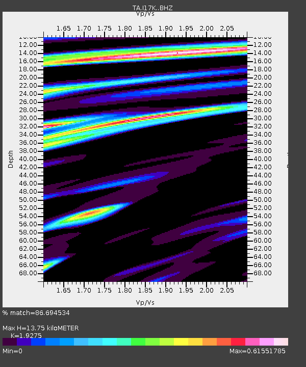
| Estimated Moho Depth: |
13.75 km |
| Estimated Crust Vp/Vs: |
1.93 |
| Assumed Crust Vp: |
6.276 km/s |
| Estimated Crust Vs: |
3.256 km/s |
| Estimated Crust Poisson's Ratio: |
0.32 |
|
| Radial Match: |
86.694534 % |
| Radial Bump: |
400 |
| Transverse Match: |
75.244606 % |
| Transverse Bump: |
400 |
| SOD ConfigId: |
13570011 |
| Insert Time: |
2019-04-29 09:21:25.951 +0000 |
| GWidth: |
2.5 |
| Max Bumps: |
400 |
| Tol: |
0.001 |
|
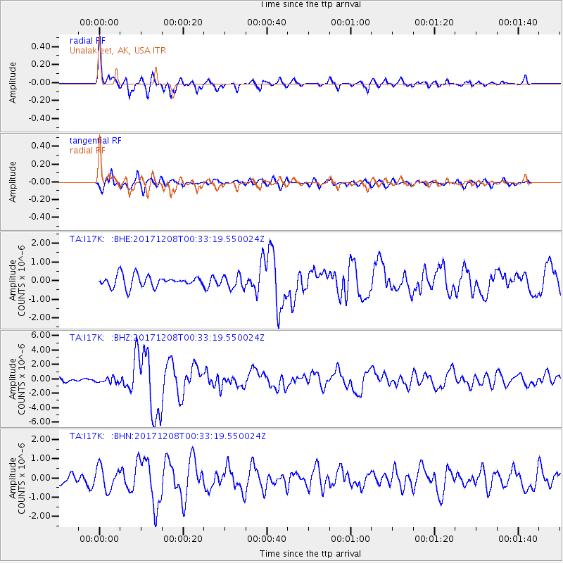
Signal To Noise
| Channel | StoN | STA | LTA |
| TA:I17K: :BHZ:20171208T00:33:19.550024Z | 1.3305968 | 3.6922512E-7 | 2.7748834E-7 |
| TA:I17K: :BHN:20171208T00:33:19.550024Z | 3.2810433 | 6.1095733E-7 | 1.8620825E-7 |
| TA:I17K: :BHE:20171208T00:33:19.550024Z | 1.1343001 | 3.4838834E-7 | 3.071395E-7 |
| Arrivals |
| Ps | 2.1 SECOND |
| PpPs | 6.2 SECOND |
| PsPs/PpSs | 8.3 SECOND |


