You are here: Home > Network List > TA - USArray Transportable Network (new EarthScope stations) Stations List
> Station J25K Salcha River, AK, USA > Earthquake Result Viewer
J25K Salcha River, AK, USA - Earthquake Result Viewer
| Earthquake location: |
W. Caroline Islands, Micronesia |
| Earthquake latitude/longitude: |
10.1/140.2 |
| Earthquake time(UTC): |
2017/12/08 (342) 00:22:53 GMT |
| Earthquake Depth: |
7.5 km |
| Earthquake Magnitude: |
6.5 mww |
| Earthquake Catalog/Contributor: |
NEIC PDE/us |
|
| Network: |
TA USArray Transportable Network (new EarthScope stations) |
| Station: |
J25K Salcha River, AK, USA |
| Lat/Lon: |
64.61 N/145.37 W |
| Elevation: |
949 m |
|
| Distance: |
74.2 deg |
| Az: |
25.563 deg |
| Baz: |
260.243 deg |
| Ray Param: |
0.052482124 |
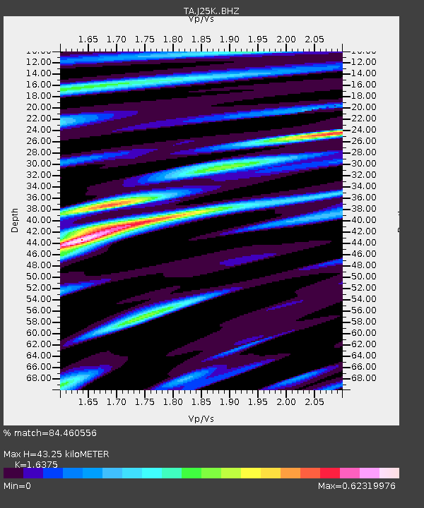
| Estimated Moho Depth: |
43.25 km |
| Estimated Crust Vp/Vs: |
1.64 |
| Assumed Crust Vp: |
6.566 km/s |
| Estimated Crust Vs: |
4.01 km/s |
| Estimated Crust Poisson's Ratio: |
0.20 |
|
| Radial Match: |
84.460556 % |
| Radial Bump: |
392 |
| Transverse Match: |
62.528057 % |
| Transverse Bump: |
400 |
| SOD ConfigId: |
13570011 |
| Insert Time: |
2019-04-29 09:21:30.161 +0000 |
| GWidth: |
2.5 |
| Max Bumps: |
400 |
| Tol: |
0.001 |
|

Signal To Noise
| Channel | StoN | STA | LTA |
| TA:J25K: :BHZ:20171208T00:33:59.525Z | 1.0866877 | 3.8565383E-7 | 3.548893E-7 |
| TA:J25K: :BHN:20171208T00:33:59.525Z | 0.8719105 | 2.968369E-7 | 3.4044425E-7 |
| TA:J25K: :BHE:20171208T00:33:59.525Z | 2.2503355 | 5.9264255E-7 | 2.633574E-7 |
| Arrivals |
| Ps | 4.4 SECOND |
| PpPs | 17 SECOND |
| PsPs/PpSs | 21 SECOND |


