You are here: Home > Network List > TA - USArray Transportable Network (new EarthScope stations) Stations List
> Station Q21A Lamborn Mesa, Paonia, CO, USA > Earthquake Result Viewer
Q21A Lamborn Mesa, Paonia, CO, USA - Earthquake Result Viewer
| Earthquake location: |
Sea Of Okhotsk |
| Earthquake latitude/longitude: |
54.2/154.3 |
| Earthquake time(UTC): |
2008/11/24 (329) 09:02:58 GMT |
| Earthquake Depth: |
492 km |
| Earthquake Magnitude: |
6.5 MB, 7.3 MW, 7.3 MW |
| Earthquake Catalog/Contributor: |
WHDF/NEIC |
|
| Network: |
TA USArray Transportable Network (new EarthScope stations) |
| Station: |
Q21A Lamborn Mesa, Paonia, CO, USA |
| Lat/Lon: |
38.83 N/107.57 W |
| Elevation: |
1881 m |
|
| Distance: |
63.9 deg |
| Az: |
59.47 deg |
| Baz: |
319.613 deg |
| Ray Param: |
0.057540473 |
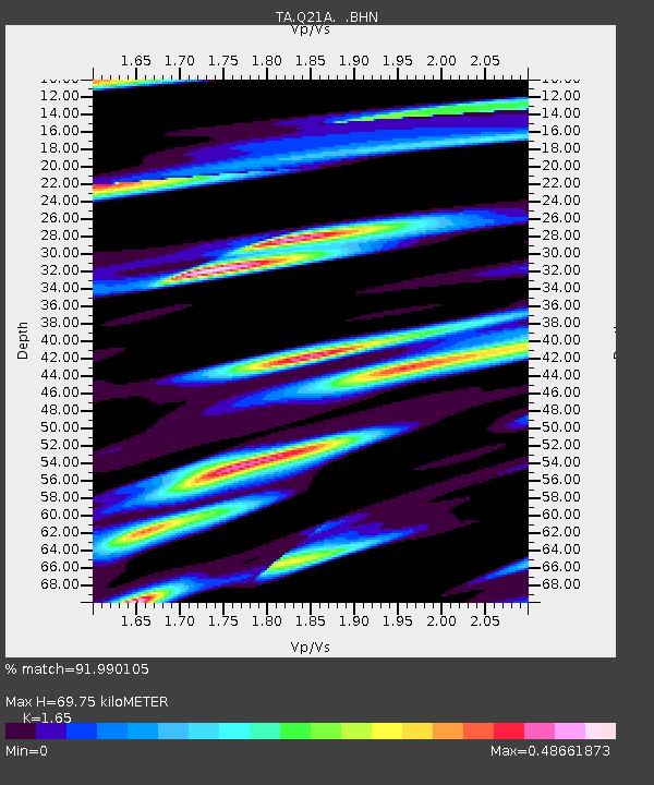
| Estimated Moho Depth: |
69.75 km |
| Estimated Crust Vp/Vs: |
1.65 |
| Assumed Crust Vp: |
6.306 km/s |
| Estimated Crust Vs: |
3.822 km/s |
| Estimated Crust Poisson's Ratio: |
0.21 |
|
| Radial Match: |
91.990105 % |
| Radial Bump: |
354 |
| Transverse Match: |
63.875786 % |
| Transverse Bump: |
400 |
| SOD ConfigId: |
2658 |
| Insert Time: |
2010-03-06 07:15:49.935 +0000 |
| GWidth: |
2.5 |
| Max Bumps: |
400 |
| Tol: |
0.001 |
|
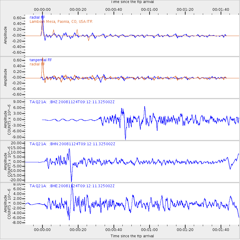
Signal To Noise
| Channel | StoN | STA | LTA |
| TA:Q21A: :BHN:20081124T09:12:11.325002Z | 13.917303 | 2.5967129E-6 | 1.8658162E-7 |
| TA:Q21A: :BHE:20081124T09:12:11.325002Z | 4.3078156 | 1.0612343E-6 | 2.4635094E-7 |
| TA:Q21A: :BHZ:20081124T09:12:11.325002Z | 3.508424 | 1.0472252E-6 | 2.9848874E-7 |
| Arrivals |
| Ps | 7.5 SECOND |
| PpPs | 28 SECOND |
| PsPs/PpSs | 36 SECOND |


