You are here: Home > Network List > AU - Australian Seismological Centre Stations List
> Station CTA Charters Towers, Queensland > Earthquake Result Viewer
CTA Charters Towers, Queensland - Earthquake Result Viewer
| Earthquake location: |
Kermadec Islands, New Zealand |
| Earthquake latitude/longitude: |
-30.6/-178.5 |
| Earthquake time(UTC): |
2017/12/08 (342) 02:09:57 GMT |
| Earthquake Depth: |
12 km |
| Earthquake Magnitude: |
5.9 Mww |
| Earthquake Catalog/Contributor: |
NEIC PDE/us |
|
| Network: |
AU Australian Seismological Centre |
| Station: |
CTA Charters Towers, Queensland |
| Lat/Lon: |
20.09 S/146.25 E |
| Elevation: |
426 m |
|
| Distance: |
33.4 deg |
| Az: |
279.81 deg |
| Baz: |
115.263 deg |
| Ray Param: |
0.07822298 |
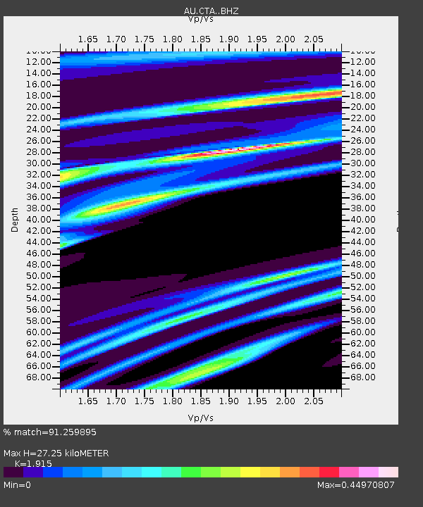
| Estimated Moho Depth: |
27.25 km |
| Estimated Crust Vp/Vs: |
1.91 |
| Assumed Crust Vp: |
6.522 km/s |
| Estimated Crust Vs: |
3.406 km/s |
| Estimated Crust Poisson's Ratio: |
0.31 |
|
| Radial Match: |
91.259895 % |
| Radial Bump: |
276 |
| Transverse Match: |
62.366776 % |
| Transverse Bump: |
400 |
| SOD ConfigId: |
13570011 |
| Insert Time: |
2019-04-29 09:23:15.555 +0000 |
| GWidth: |
2.5 |
| Max Bumps: |
400 |
| Tol: |
0.001 |
|

Signal To Noise
| Channel | StoN | STA | LTA |
| AU:CTA: :BHZ:20171208T02:16:05.050006Z | 3.1116712 | 6.223629E-7 | 2.000092E-7 |
| AU:CTA: :BHN:20171208T02:16:05.050006Z | 0.87434375 | 1.6112192E-7 | 1.8427754E-7 |
| AU:CTA: :BHE:20171208T02:16:05.050006Z | 4.50873 | 4.2033355E-7 | 9.3226596E-8 |
| Arrivals |
| Ps | 4.1 SECOND |
| PpPs | 11 SECOND |
| PsPs/PpSs | 15 SECOND |


