You are here: Home > Network List > TA - USArray Transportable Network (new EarthScope stations) Stations List
> Station Q21A Lamborn Mesa, Paonia, CO, USA > Earthquake Result Viewer
Q21A Lamborn Mesa, Paonia, CO, USA - Earthquake Result Viewer
| Earthquake location: |
Andreanof Islands, Aleutian Is. |
| Earthquake latitude/longitude: |
51.5/-178.3 |
| Earthquake time(UTC): |
2009/03/30 (089) 12:11:54 GMT |
| Earthquake Depth: |
31 km |
| Earthquake Magnitude: |
6.0 MB, 5.8 MW, 5.7 MW |
| Earthquake Catalog/Contributor: |
WHDF/NEIC |
|
| Network: |
TA USArray Transportable Network (new EarthScope stations) |
| Station: |
Q21A Lamborn Mesa, Paonia, CO, USA |
| Lat/Lon: |
38.83 N/107.57 W |
| Elevation: |
1881 m |
|
| Distance: |
49.5 deg |
| Az: |
75.654 deg |
| Baz: |
309.2 deg |
| Ray Param: |
0.068581626 |
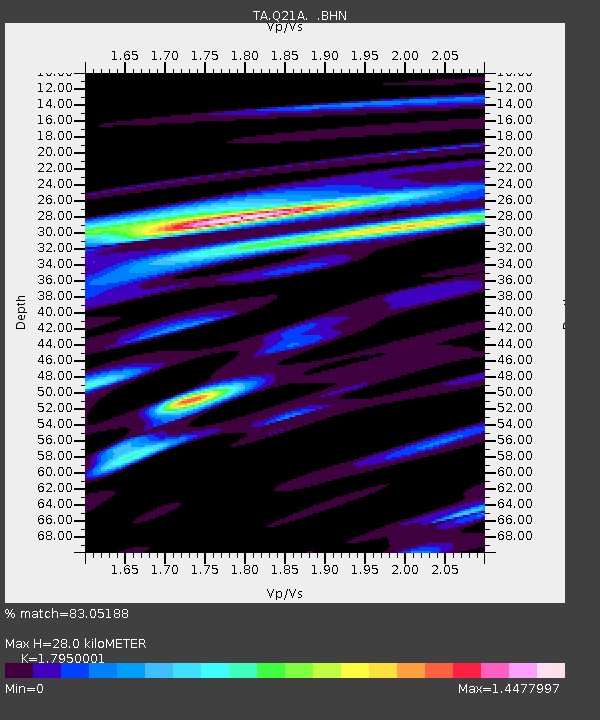
| Estimated Moho Depth: |
28.0 km |
| Estimated Crust Vp/Vs: |
1.80 |
| Assumed Crust Vp: |
6.306 km/s |
| Estimated Crust Vs: |
3.513 km/s |
| Estimated Crust Poisson's Ratio: |
0.27 |
|
| Radial Match: |
83.05188 % |
| Radial Bump: |
400 |
| Transverse Match: |
75.95633 % |
| Transverse Bump: |
400 |
| SOD ConfigId: |
2658 |
| Insert Time: |
2010-03-06 07:16:12.594 +0000 |
| GWidth: |
2.5 |
| Max Bumps: |
400 |
| Tol: |
0.001 |
|
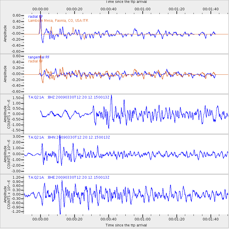
Signal To Noise
| Channel | StoN | STA | LTA |
| TA:Q21A: :BHN:20090330T12:20:12.150013Z | 3.2592633 | 7.7219283E-7 | 2.369225E-7 |
| TA:Q21A: :BHE:20090330T12:20:12.150013Z | 4.193602 | 3.7162283E-7 | 8.8616616E-8 |
| TA:Q21A: :BHZ:20090330T12:20:12.150013Z | 2.288117 | 4.3501828E-7 | 1.9012066E-7 |
| Arrivals |
| Ps | 3.7 SECOND |
| PpPs | 12 SECOND |
| PsPs/PpSs | 15 SECOND |


