You are here: Home > Network List > TA - USArray Transportable Network (new EarthScope stations) Stations List
> Station Q21A Lamborn Mesa, Paonia, CO, USA > Earthquake Result Viewer
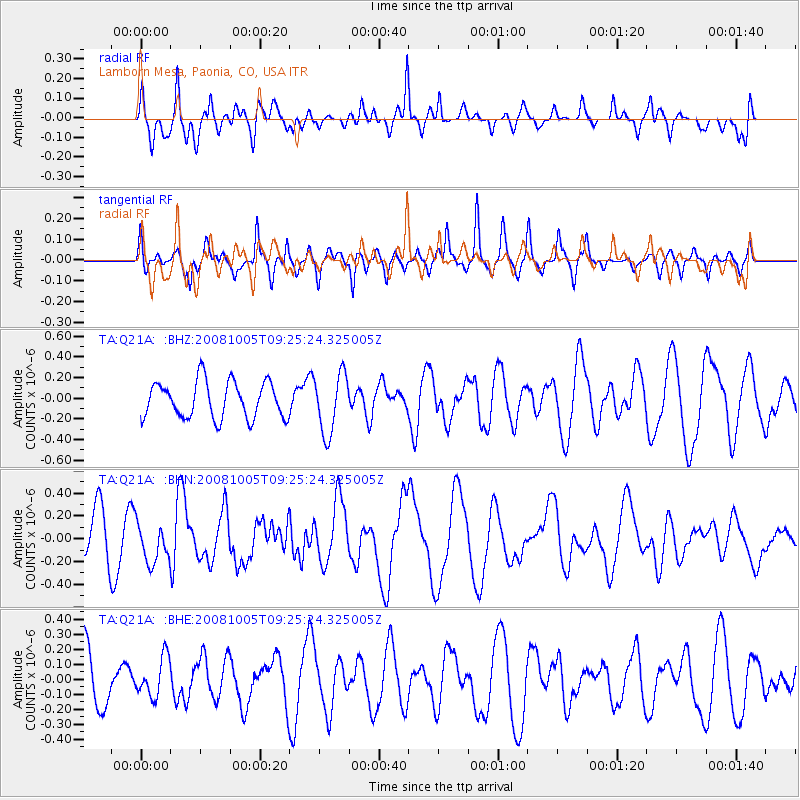
Q21A Lamborn Mesa, Paonia, CO, USA - Earthquake Result Viewer
*The percent match for this event was below the threshold and hence no stack was calculated.
| Earthquake location: |
Kermadec Islands, New Zealand |
| Earthquake latitude/longitude: |
-30.2/-177.2 |
| Earthquake time(UTC): |
2008/10/05 (279) 09:12:36 GMT |
| Earthquake Depth: |
10 km |
| Earthquake Magnitude: |
5.8 MB, 6.2 MS, 6.2 MW, 6.1 MW |
| Earthquake Catalog/Contributor: |
WHDF/NEIC |
|
| Network: |
TA USArray Transportable Network (new EarthScope stations) |
| Station: |
Q21A Lamborn Mesa, Paonia, CO, USA |
| Lat/Lon: |
38.83 N/107.57 W |
| Elevation: |
1881 m |
|
| Distance: |
94.4 deg |
| Az: |
47.24 deg |
| Baz: |
234.487 deg |
| Ray Param: |
$rayparam |
*The percent match for this event was below the threshold and hence was not used in the summary stack. |
|
| Radial Match: |
54.07584 % |
| Radial Bump: |
400 |
| Transverse Match: |
80.485 % |
| Transverse Bump: |
400 |
| SOD ConfigId: |
2556 |
| Insert Time: |
2010-03-06 07:16:17.049 +0000 |
| GWidth: |
2.5 |
| Max Bumps: |
400 |
| Tol: |
0.001 |
|
Signal To Noise
| Channel | StoN | STA | LTA |
| TA:Q21A: :BHN:20081005T09:25:24.325005Z | 0.5272026 | 1.6734336E-7 | 3.1741754E-7 |
| TA:Q21A: :BHE:20081005T09:25:24.325005Z | 0.9048024 | 1.3020316E-7 | 1.4390233E-7 |
| TA:Q21A: :BHZ:20081005T09:25:24.325005Z | 1.6316284 | 2.8694188E-7 | 1.7586228E-7 |
| Arrivals |
| Ps | |
| PpPs | |
| PsPs/PpSs | |


