You are here: Home > Network List > CI - Caltech Regional Seismic Network Stations List
> Station SWS Sam W. Stewart, Westmorland, CA, USA > Earthquake Result Viewer
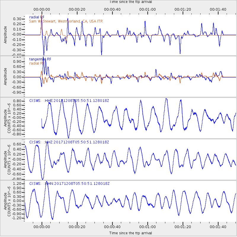
SWS Sam W. Stewart, Westmorland, CA, USA - Earthquake Result Viewer
*The percent match for this event was below the threshold and hence no stack was calculated.
| Earthquake location: |
W. Caroline Islands, Micronesia |
| Earthquake latitude/longitude: |
10.0/140.1 |
| Earthquake time(UTC): |
2017/12/08 (342) 05:37:54 GMT |
| Earthquake Depth: |
10 km |
| Earthquake Magnitude: |
5.5 mb |
| Earthquake Catalog/Contributor: |
NEIC PDE/us |
|
| Network: |
CI Caltech Regional Seismic Network |
| Station: |
SWS Sam W. Stewart, Westmorland, CA, USA |
| Lat/Lon: |
32.94 N/115.80 W |
| Elevation: |
140 m |
|
| Distance: |
96.2 deg |
| Az: |
55.13 deg |
| Baz: |
286.032 deg |
| Ray Param: |
$rayparam |
*The percent match for this event was below the threshold and hence was not used in the summary stack. |
|
| Radial Match: |
72.915695 % |
| Radial Bump: |
378 |
| Transverse Match: |
66.37866 % |
| Transverse Bump: |
400 |
| SOD ConfigId: |
13570011 |
| Insert Time: |
2019-04-29 09:29:02.436 +0000 |
| GWidth: |
2.5 |
| Max Bumps: |
400 |
| Tol: |
0.001 |
|
Signal To Noise
| Channel | StoN | STA | LTA |
| CI:SWS: :HHZ:20171208T05:50:51.128018Z | 1.8340037 | 5.1368266E-7 | 2.8008813E-7 |
| CI:SWS: :HHN:20171208T05:50:51.128018Z | 1.6502934 | 8.9069295E-7 | 5.39718E-7 |
| CI:SWS: :HHE:20171208T05:50:51.128018Z | 0.8462068 | 4.4920554E-7 | 5.308461E-7 |
| Arrivals |
| Ps | |
| PpPs | |
| PsPs/PpSs | |


