You are here: Home > Network List > TA - USArray Transportable Network (new EarthScope stations) Stations List
> Station I17K Unalakleet, AK, USA > Earthquake Result Viewer
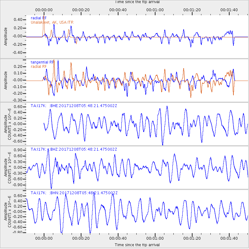
I17K Unalakleet, AK, USA - Earthquake Result Viewer
*The percent match for this event was below the threshold and hence no stack was calculated.
| Earthquake location: |
W. Caroline Islands, Micronesia |
| Earthquake latitude/longitude: |
10.0/140.1 |
| Earthquake time(UTC): |
2017/12/08 (342) 05:37:54 GMT |
| Earthquake Depth: |
10 km |
| Earthquake Magnitude: |
5.5 mb |
| Earthquake Catalog/Contributor: |
NEIC PDE/us |
|
| Network: |
TA USArray Transportable Network (new EarthScope stations) |
| Station: |
I17K Unalakleet, AK, USA |
| Lat/Lon: |
63.89 N/160.70 W |
| Elevation: |
105 m |
|
| Distance: |
67.8 deg |
| Az: |
24.235 deg |
| Baz: |
246.018 deg |
| Ray Param: |
$rayparam |
*The percent match for this event was below the threshold and hence was not used in the summary stack. |
|
| Radial Match: |
59.612015 % |
| Radial Bump: |
400 |
| Transverse Match: |
59.571487 % |
| Transverse Bump: |
339 |
| SOD ConfigId: |
13570011 |
| Insert Time: |
2019-04-29 09:30:51.640 +0000 |
| GWidth: |
2.5 |
| Max Bumps: |
400 |
| Tol: |
0.001 |
|
Signal To Noise
| Channel | StoN | STA | LTA |
| TA:I17K: :BHZ:20171208T05:48:21.475002Z | 2.5826552 | 5.6164083E-7 | 2.1746644E-7 |
| TA:I17K: :BHN:20171208T05:48:21.475002Z | 0.7027832 | 2.3586291E-7 | 3.356126E-7 |
| TA:I17K: :BHE:20171208T05:48:21.475002Z | 0.6922799 | 1.8361719E-7 | 2.6523549E-7 |
| Arrivals |
| Ps | |
| PpPs | |
| PsPs/PpSs | |


