You are here: Home > Network List > TA - USArray Transportable Network (new EarthScope stations) Stations List
> Station Q21A Lamborn Mesa, Paonia, CO, USA > Earthquake Result Viewer
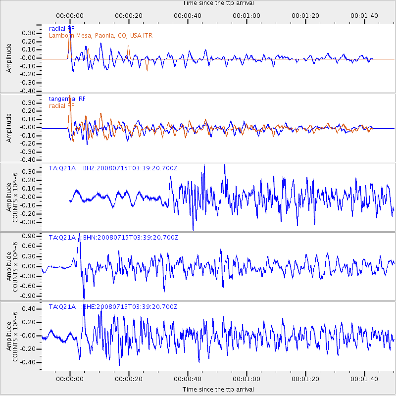
Q21A Lamborn Mesa, Paonia, CO, USA - Earthquake Result Viewer
*The percent match for this event was below the threshold and hence no stack was calculated.
| Earthquake location: |
Dodecanese Islands, Greece |
| Earthquake latitude/longitude: |
35.8/27.9 |
| Earthquake time(UTC): |
2008/07/15 (197) 03:26:34 GMT |
| Earthquake Depth: |
52 km |
| Earthquake Magnitude: |
6.5 MB, 6.4 MW, 6.4 MW |
| Earthquake Catalog/Contributor: |
WHDF/NEIC |
|
| Network: |
TA USArray Transportable Network (new EarthScope stations) |
| Station: |
Q21A Lamborn Mesa, Paonia, CO, USA |
| Lat/Lon: |
38.83 N/107.57 W |
| Elevation: |
1881 m |
|
| Distance: |
95.1 deg |
| Az: |
326.618 deg |
| Baz: |
34.939 deg |
| Ray Param: |
$rayparam |
*The percent match for this event was below the threshold and hence was not used in the summary stack. |
|
| Radial Match: |
76.10543 % |
| Radial Bump: |
400 |
| Transverse Match: |
72.27875 % |
| Transverse Bump: |
400 |
| SOD ConfigId: |
2504 |
| Insert Time: |
2010-03-06 07:16:47.134 +0000 |
| GWidth: |
2.5 |
| Max Bumps: |
400 |
| Tol: |
0.001 |
|
Signal To Noise
| Channel | StoN | STA | LTA |
| TA:Q21A: :BHN:20080715T03:39:20.700Z | 7.033536 | 4.3702008E-7 | 6.2133765E-8 |
| TA:Q21A: :BHE:20080715T03:39:20.700Z | 3.8943422 | 1.6807353E-7 | 4.3158387E-8 |
| TA:Q21A: :BHZ:20080715T03:39:20.700Z | 2.0624723 | 9.419239E-8 | 4.566965E-8 |
| Arrivals |
| Ps | |
| PpPs | |
| PsPs/PpSs | |


