You are here: Home > Network List > TA - USArray Transportable Network (new EarthScope stations) Stations List
> Station Q21A Lamborn Mesa, Paonia, CO, USA > Earthquake Result Viewer
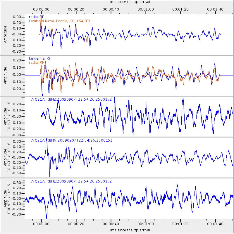
Q21A Lamborn Mesa, Paonia, CO, USA - Earthquake Result Viewer
*The percent match for this event was below the threshold and hence no stack was calculated.
| Earthquake location: |
Northwestern Caucasus |
| Earthquake latitude/longitude: |
42.7/43.4 |
| Earthquake time(UTC): |
2009/09/07 (250) 22:41:37 GMT |
| Earthquake Depth: |
15 km |
| Earthquake Magnitude: |
5.7 MB, 5.8 MS, 6.0 MW, 5.9 MW |
| Earthquake Catalog/Contributor: |
WHDF/NEIC |
|
| Network: |
TA USArray Transportable Network (new EarthScope stations) |
| Station: |
Q21A Lamborn Mesa, Paonia, CO, USA |
| Lat/Lon: |
38.83 N/107.57 W |
| Elevation: |
1881 m |
|
| Distance: |
94.7 deg |
| Az: |
337.683 deg |
| Baz: |
21.017 deg |
| Ray Param: |
$rayparam |
*The percent match for this event was below the threshold and hence was not used in the summary stack. |
|
| Radial Match: |
59.778774 % |
| Radial Bump: |
400 |
| Transverse Match: |
75.128494 % |
| Transverse Bump: |
400 |
| SOD ConfigId: |
2622 |
| Insert Time: |
2010-03-06 07:17:15.476 +0000 |
| GWidth: |
2.5 |
| Max Bumps: |
400 |
| Tol: |
0.001 |
|
Signal To Noise
| Channel | StoN | STA | LTA |
| TA:Q21A: :BHN:20090907T22:54:26.250015Z | 3.041336 | 2.8449836E-7 | 9.354387E-8 |
| TA:Q21A: :BHE:20090907T22:54:26.250015Z | 1.5042956 | 1.5541568E-7 | 1.03314584E-7 |
| TA:Q21A: :BHZ:20090907T22:54:26.250015Z | 1.338961 | 1.2188339E-7 | 9.102833E-8 |
| Arrivals |
| Ps | |
| PpPs | |
| PsPs/PpSs | |


