You are here: Home > Network List > S - Seismographs in Schools Projects Stations List
> Station AUNRC North Rockhampton State High School, QLD > Earthquake Result Viewer
AUNRC North Rockhampton State High School, QLD - Earthquake Result Viewer
| Earthquake location: |
W. Caroline Islands, Micronesia |
| Earthquake latitude/longitude: |
10.0/140.1 |
| Earthquake time(UTC): |
2017/12/08 (342) 09:51:10 GMT |
| Earthquake Depth: |
20 km |
| Earthquake Magnitude: |
6.4 Mww |
| Earthquake Catalog/Contributor: |
NEIC PDE/us |
|
| Network: |
S Seismographs in Schools Projects |
| Station: |
AUNRC North Rockhampton State High School, QLD |
| Lat/Lon: |
23.35 S/150.53 E |
| Elevation: |
38 m |
|
| Distance: |
34.7 deg |
| Az: |
163.047 deg |
| Baz: |
341.79 deg |
| Ray Param: |
0.07759025 |
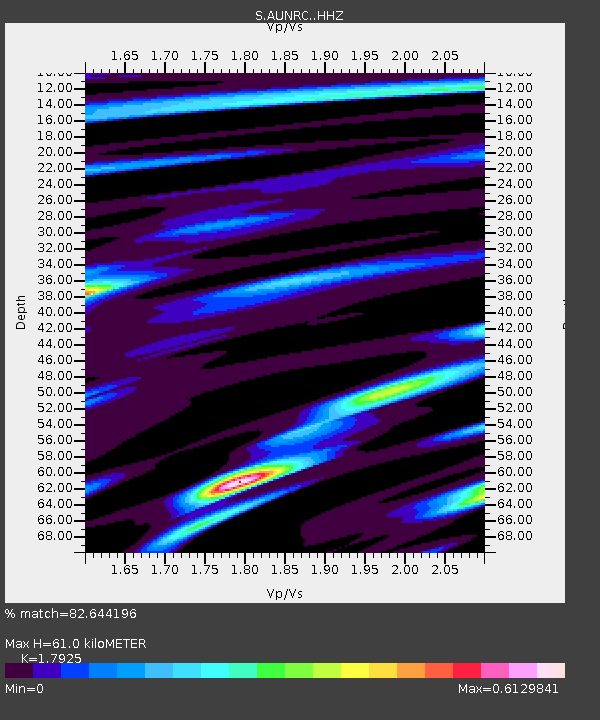
| Estimated Moho Depth: |
61.0 km |
| Estimated Crust Vp/Vs: |
1.79 |
| Assumed Crust Vp: |
6.472 km/s |
| Estimated Crust Vs: |
3.611 km/s |
| Estimated Crust Poisson's Ratio: |
0.27 |
|
| Radial Match: |
82.644196 % |
| Radial Bump: |
315 |
| Transverse Match: |
72.18074 % |
| Transverse Bump: |
400 |
| SOD ConfigId: |
13570011 |
| Insert Time: |
2019-04-29 09:36:28.636 +0000 |
| GWidth: |
2.5 |
| Max Bumps: |
400 |
| Tol: |
0.001 |
|

Signal To Noise
| Channel | StoN | STA | LTA |
| S:AUNRC: :HHZ:20171208T09:57:27.840009Z | 6.22839 | 1.2973239E-6 | 2.0829202E-7 |
| S:AUNRC: :HHN:20171208T09:57:27.840009Z | 4.270627 | 8.4974687E-7 | 1.9897472E-7 |
| S:AUNRC: :HHE:20171208T09:57:27.840009Z | 3.0186727 | 4.728783E-7 | 1.5665107E-7 |
| Arrivals |
| Ps | 8.1 SECOND |
| PpPs | 24 SECOND |
| PsPs/PpSs | 32 SECOND |


