You are here: Home > Network List > TA - USArray Transportable Network (new EarthScope stations) Stations List
> Station Q21A Lamborn Mesa, Paonia, CO, USA > Earthquake Result Viewer
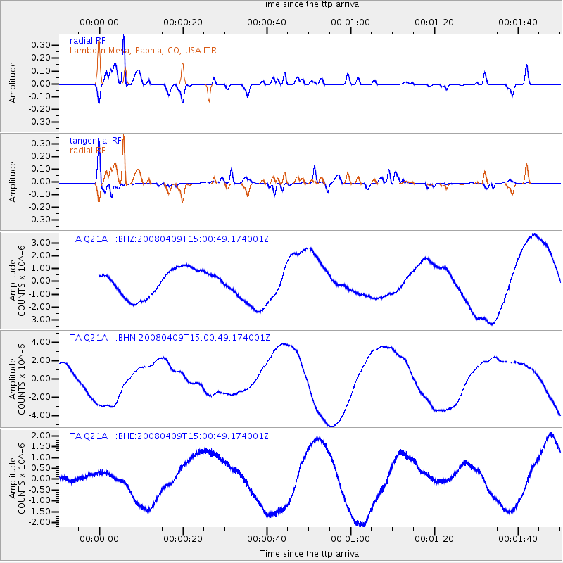
Q21A Lamborn Mesa, Paonia, CO, USA - Earthquake Result Viewer
*The percent match for this event was below the threshold and hence no stack was calculated.
| Earthquake location: |
Vanuatu Islands |
| Earthquake latitude/longitude: |
-20.0/168.9 |
| Earthquake time(UTC): |
2008/04/09 (100) 14:47:50 GMT |
| Earthquake Depth: |
35 km |
| Earthquake Magnitude: |
5.9 MB, 6.2 MS, 6.3 MW |
| Earthquake Catalog/Contributor: |
WHDF/NEIC |
|
| Network: |
TA USArray Transportable Network (new EarthScope stations) |
| Station: |
Q21A Lamborn Mesa, Paonia, CO, USA |
| Lat/Lon: |
38.83 N/107.57 W |
| Elevation: |
1881 m |
|
| Distance: |
97.5 deg |
| Az: |
51.508 deg |
| Baz: |
250.471 deg |
| Ray Param: |
$rayparam |
*The percent match for this event was below the threshold and hence was not used in the summary stack. |
|
| Radial Match: |
90.1896 % |
| Radial Bump: |
278 |
| Transverse Match: |
80.16593 % |
| Transverse Bump: |
220 |
| SOD ConfigId: |
2504 |
| Insert Time: |
2010-03-06 07:18:01.886 +0000 |
| GWidth: |
2.5 |
| Max Bumps: |
400 |
| Tol: |
0.001 |
|
Signal To Noise
| Channel | StoN | STA | LTA |
| TA:Q21A: :BHN:20080409T15:00:49.174001Z | 3.421536 | 3.1204681E-6 | 9.12008E-7 |
| TA:Q21A: :BHE:20080409T15:00:49.174001Z | 1.2416251 | 3.171887E-7 | 2.5546257E-7 |
| TA:Q21A: :BHZ:20080409T15:00:49.174001Z | 0.77052885 | 8.091711E-7 | 1.0501503E-6 |
| Arrivals |
| Ps | |
| PpPs | |
| PsPs/PpSs | |


