You are here: Home > Network List > TA - USArray Transportable Network (new EarthScope stations) Stations List
> Station F20K Avaraart Lake, AK, USA > Earthquake Result Viewer
F20K Avaraart Lake, AK, USA - Earthquake Result Viewer
| Earthquake location: |
W. Caroline Islands, Micronesia |
| Earthquake latitude/longitude: |
10.0/140.1 |
| Earthquake time(UTC): |
2017/12/08 (342) 09:51:10 GMT |
| Earthquake Depth: |
20 km |
| Earthquake Magnitude: |
6.4 Mww |
| Earthquake Catalog/Contributor: |
NEIC PDE/us |
|
| Network: |
TA USArray Transportable Network (new EarthScope stations) |
| Station: |
F20K Avaraart Lake, AK, USA |
| Lat/Lon: |
67.05 N/155.73 W |
| Elevation: |
136 m |
|
| Distance: |
70.9 deg |
| Az: |
21.931 deg |
| Baz: |
249.725 deg |
| Ray Param: |
0.05465961 |
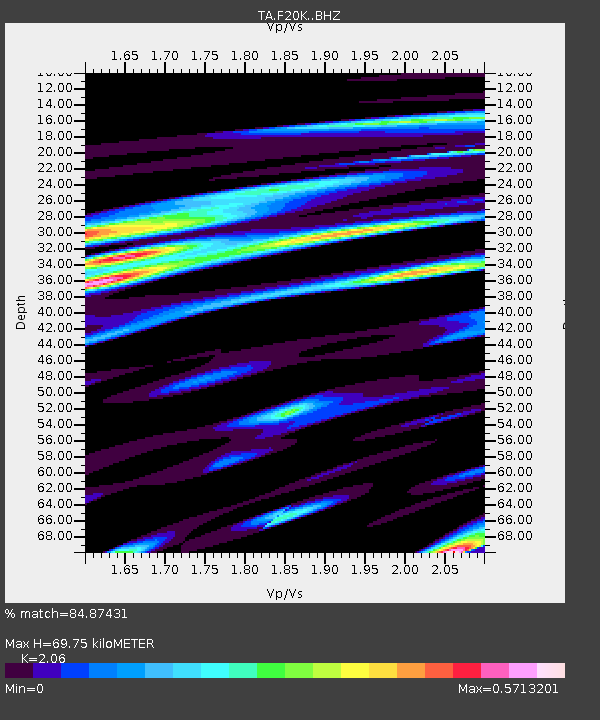
| Estimated Moho Depth: |
69.75 km |
| Estimated Crust Vp/Vs: |
2.06 |
| Assumed Crust Vp: |
6.522 km/s |
| Estimated Crust Vs: |
3.166 km/s |
| Estimated Crust Poisson's Ratio: |
0.35 |
|
| Radial Match: |
84.87431 % |
| Radial Bump: |
400 |
| Transverse Match: |
73.49464 % |
| Transverse Bump: |
400 |
| SOD ConfigId: |
13570011 |
| Insert Time: |
2019-04-29 09:37:05.504 +0000 |
| GWidth: |
2.5 |
| Max Bumps: |
400 |
| Tol: |
0.001 |
|
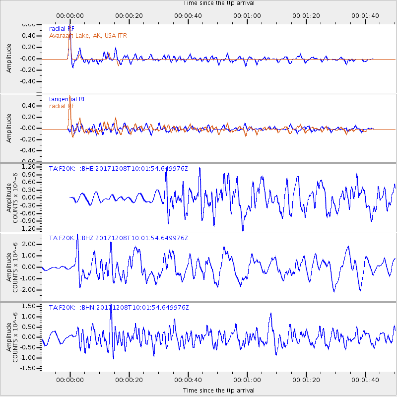
Signal To Noise
| Channel | StoN | STA | LTA |
| TA:F20K: :BHZ:20171208T10:01:54.649976Z | 8.307942 | 1.0661353E-6 | 1.2832724E-7 |
| TA:F20K: :BHN:20171208T10:01:54.649976Z | 1.22376 | 2.6282945E-7 | 2.1477206E-7 |
| TA:F20K: :BHE:20171208T10:01:54.649976Z | 4.075049 | 4.6190684E-7 | 1.1335001E-7 |
| Arrivals |
| Ps | 12 SECOND |
| PpPs | 32 SECOND |
| PsPs/PpSs | 43 SECOND |


