You are here: Home > Network List > TA - USArray Transportable Network (new EarthScope stations) Stations List
> Station G31M Satah River, YT, CAN > Earthquake Result Viewer
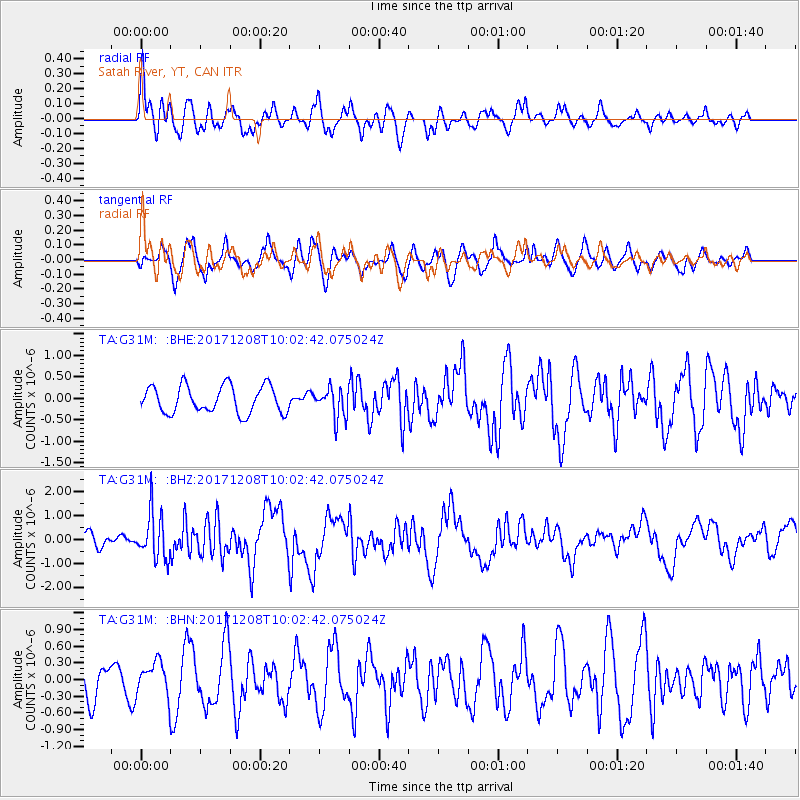
G31M Satah River, YT, CAN - Earthquake Result Viewer
*The percent match for this event was below the threshold and hence no stack was calculated.
| Earthquake location: |
W. Caroline Islands, Micronesia |
| Earthquake latitude/longitude: |
10.0/140.1 |
| Earthquake time(UTC): |
2017/12/08 (342) 09:51:10 GMT |
| Earthquake Depth: |
20 km |
| Earthquake Magnitude: |
6.4 Mww |
| Earthquake Catalog/Contributor: |
NEIC PDE/us |
|
| Network: |
TA USArray Transportable Network (new EarthScope stations) |
| Station: |
G31M Satah River, YT, CAN |
| Lat/Lon: |
66.92 N/134.27 W |
| Elevation: |
61 m |
|
| Distance: |
79.1 deg |
| Az: |
23.592 deg |
| Baz: |
269.917 deg |
| Ray Param: |
$rayparam |
*The percent match for this event was below the threshold and hence was not used in the summary stack. |
|
| Radial Match: |
64.45988 % |
| Radial Bump: |
392 |
| Transverse Match: |
66.10628 % |
| Transverse Bump: |
400 |
| SOD ConfigId: |
13570011 |
| Insert Time: |
2019-04-29 09:37:22.113 +0000 |
| GWidth: |
2.5 |
| Max Bumps: |
400 |
| Tol: |
0.001 |
|
Signal To Noise
| Channel | StoN | STA | LTA |
| TA:G31M: :BHZ:20171208T10:02:42.075024Z | 4.471123 | 9.67778E-7 | 2.1645077E-7 |
| TA:G31M: :BHN:20171208T10:02:42.075024Z | 0.88801813 | 2.9585604E-7 | 3.3316442E-7 |
| TA:G31M: :BHE:20171208T10:02:42.075024Z | 1.0957885 | 3.4548975E-7 | 3.152887E-7 |
| Arrivals |
| Ps | |
| PpPs | |
| PsPs/PpSs | |


