You are here: Home > Network List > TA - USArray Transportable Network (new EarthScope stations) Stations List
> Station H24K Noodor Dome, AK, USA > Earthquake Result Viewer
H24K Noodor Dome, AK, USA - Earthquake Result Viewer
| Earthquake location: |
W. Caroline Islands, Micronesia |
| Earthquake latitude/longitude: |
10.0/140.1 |
| Earthquake time(UTC): |
2017/12/08 (342) 09:51:10 GMT |
| Earthquake Depth: |
20 km |
| Earthquake Magnitude: |
6.4 Mww |
| Earthquake Catalog/Contributor: |
NEIC PDE/us |
|
| Network: |
TA USArray Transportable Network (new EarthScope stations) |
| Station: |
H24K Noodor Dome, AK, USA |
| Lat/Lon: |
65.84 N/147.88 W |
| Elevation: |
814 m |
|
| Distance: |
73.6 deg |
| Az: |
24.086 deg |
| Baz: |
257.57 deg |
| Ray Param: |
0.052891232 |
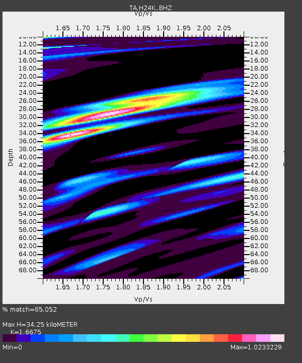
| Estimated Moho Depth: |
34.25 km |
| Estimated Crust Vp/Vs: |
1.67 |
| Assumed Crust Vp: |
6.566 km/s |
| Estimated Crust Vs: |
3.938 km/s |
| Estimated Crust Poisson's Ratio: |
0.22 |
|
| Radial Match: |
85.052 % |
| Radial Bump: |
400 |
| Transverse Match: |
76.45733 % |
| Transverse Bump: |
400 |
| SOD ConfigId: |
13570011 |
| Insert Time: |
2019-04-29 09:37:27.404 +0000 |
| GWidth: |
2.5 |
| Max Bumps: |
400 |
| Tol: |
0.001 |
|

Signal To Noise
| Channel | StoN | STA | LTA |
| TA:H24K: :BHZ:20171208T10:02:10.649976Z | 9.910535 | 1.5195728E-6 | 1.5332904E-7 |
| TA:H24K: :BHN:20171208T10:02:10.649976Z | 1.2644508 | 2.817739E-7 | 2.2284291E-7 |
| TA:H24K: :BHE:20171208T10:02:10.649976Z | 3.4247477 | 5.22608E-7 | 1.5259752E-7 |
| Arrivals |
| Ps | 3.6 SECOND |
| PpPs | 13 SECOND |
| PsPs/PpSs | 17 SECOND |


