You are here: Home > Network List > TA - USArray Transportable Network (new EarthScope stations) Stations List
> Station N19K Bonanza Creek NPS repeater, AK, USA > Earthquake Result Viewer
N19K Bonanza Creek NPS repeater, AK, USA - Earthquake Result Viewer
| Earthquake location: |
W. Caroline Islands, Micronesia |
| Earthquake latitude/longitude: |
10.0/140.1 |
| Earthquake time(UTC): |
2017/12/08 (342) 09:51:10 GMT |
| Earthquake Depth: |
20 km |
| Earthquake Magnitude: |
6.4 Mww |
| Earthquake Catalog/Contributor: |
NEIC PDE/us |
|
| Network: |
TA USArray Transportable Network (new EarthScope stations) |
| Station: |
N19K Bonanza Creek NPS repeater, AK, USA |
| Lat/Lon: |
60.81 N/154.48 W |
| Elevation: |
1144 m |
|
| Distance: |
69.4 deg |
| Az: |
28.425 deg |
| Baz: |
253.047 deg |
| Ray Param: |
0.055642 |
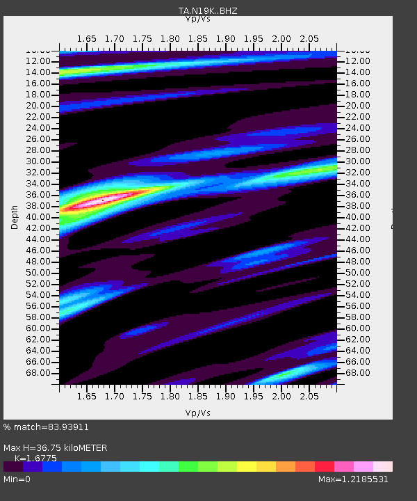
| Estimated Moho Depth: |
36.75 km |
| Estimated Crust Vp/Vs: |
1.68 |
| Assumed Crust Vp: |
6.566 km/s |
| Estimated Crust Vs: |
3.914 km/s |
| Estimated Crust Poisson's Ratio: |
0.22 |
|
| Radial Match: |
83.93911 % |
| Radial Bump: |
400 |
| Transverse Match: |
59.69865 % |
| Transverse Bump: |
400 |
| SOD ConfigId: |
13570011 |
| Insert Time: |
2019-04-29 09:38:07.243 +0000 |
| GWidth: |
2.5 |
| Max Bumps: |
400 |
| Tol: |
0.001 |
|

Signal To Noise
| Channel | StoN | STA | LTA |
| TA:N19K: :BHZ:20171208T10:01:45.599988Z | 3.4551642 | 1.4589793E-6 | 4.222605E-7 |
| TA:N19K: :BHN:20171208T10:01:45.599988Z | 1.0921991 | 3.7091272E-7 | 3.3960174E-7 |
| TA:N19K: :BHE:20171208T10:01:45.599988Z | 1.7262975 | 3.8985567E-7 | 2.2583342E-7 |
| Arrivals |
| Ps | 4.0 SECOND |
| PpPs | 14 SECOND |
| PsPs/PpSs | 18 SECOND |


