You are here: Home > Network List > TA - USArray Transportable Network (new EarthScope stations) Stations List
> Station P17K Kvichak River, AK, USA > Earthquake Result Viewer
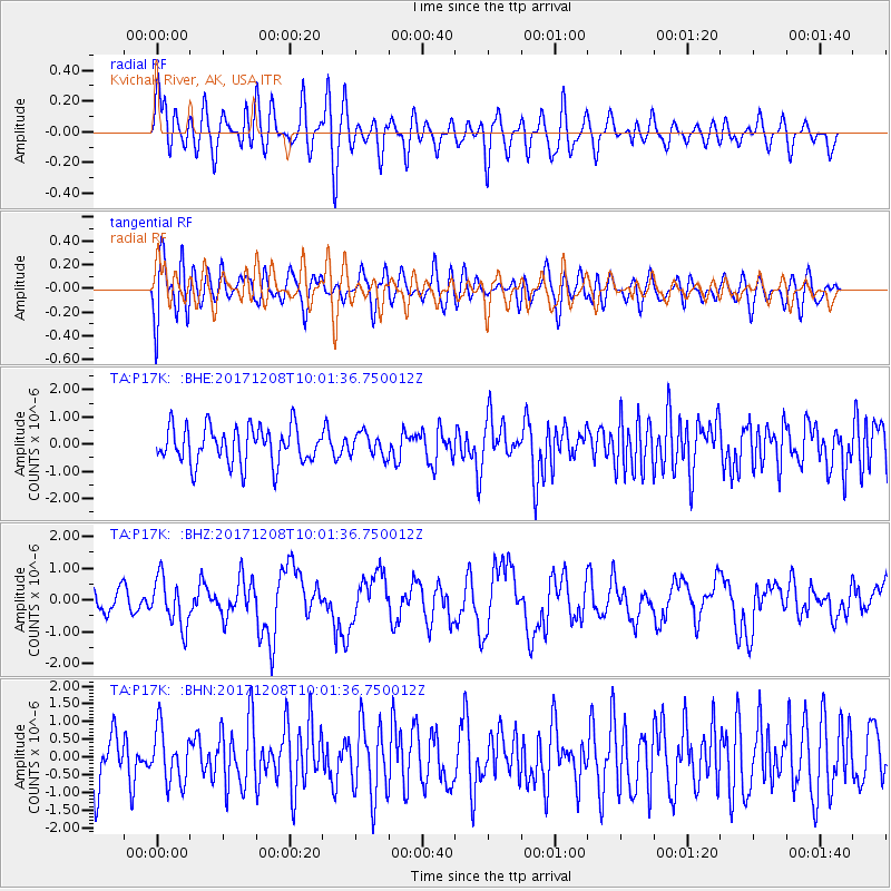
P17K Kvichak River, AK, USA - Earthquake Result Viewer
*The percent match for this event was below the threshold and hence no stack was calculated.
| Earthquake location: |
W. Caroline Islands, Micronesia |
| Earthquake latitude/longitude: |
10.0/140.1 |
| Earthquake time(UTC): |
2017/12/08 (342) 09:51:10 GMT |
| Earthquake Depth: |
20 km |
| Earthquake Magnitude: |
6.4 Mww |
| Earthquake Catalog/Contributor: |
NEIC PDE/us |
|
| Network: |
TA USArray Transportable Network (new EarthScope stations) |
| Station: |
P17K Kvichak River, AK, USA |
| Lat/Lon: |
59.20 N/156.44 W |
| Elevation: |
91 m |
|
| Distance: |
68.0 deg |
| Az: |
29.768 deg |
| Baz: |
251.844 deg |
| Ray Param: |
$rayparam |
*The percent match for this event was below the threshold and hence was not used in the summary stack. |
|
| Radial Match: |
57.966755 % |
| Radial Bump: |
400 |
| Transverse Match: |
51.9394 % |
| Transverse Bump: |
400 |
| SOD ConfigId: |
13570011 |
| Insert Time: |
2019-04-29 09:38:17.786 +0000 |
| GWidth: |
2.5 |
| Max Bumps: |
400 |
| Tol: |
0.001 |
|
Signal To Noise
| Channel | StoN | STA | LTA |
| TA:P17K: :BHZ:20171208T10:01:36.750012Z | 2.3629093 | 7.6454853E-7 | 3.2356238E-7 |
| TA:P17K: :BHN:20171208T10:01:36.750012Z | 1.1805065 | 7.553981E-7 | 6.3989324E-7 |
| TA:P17K: :BHE:20171208T10:01:36.750012Z | 0.628139 | 4.250046E-7 | 6.766091E-7 |
| Arrivals |
| Ps | |
| PpPs | |
| PsPs/PpSs | |


