You are here: Home > Network List > TJ - Tajikistan National Seismic Network Stations List
> Station CHRDR Chorukh Dayron, Tajikistan > Earthquake Result Viewer
CHRDR Chorukh Dayron, Tajikistan - Earthquake Result Viewer
| Earthquake location: |
W. Caroline Islands, Micronesia |
| Earthquake latitude/longitude: |
10.0/140.1 |
| Earthquake time(UTC): |
2017/12/08 (342) 09:51:10 GMT |
| Earthquake Depth: |
20 km |
| Earthquake Magnitude: |
6.4 Mww |
| Earthquake Catalog/Contributor: |
NEIC PDE/us |
|
| Network: |
TJ Tajikistan National Seismic Network |
| Station: |
CHRDR Chorukh Dayron, Tajikistan |
| Lat/Lon: |
40.39 N/69.67 E |
| Elevation: |
580 m |
|
| Distance: |
68.7 deg |
| Az: |
309.415 deg |
| Baz: |
94.97 deg |
| Ray Param: |
0.056104463 |
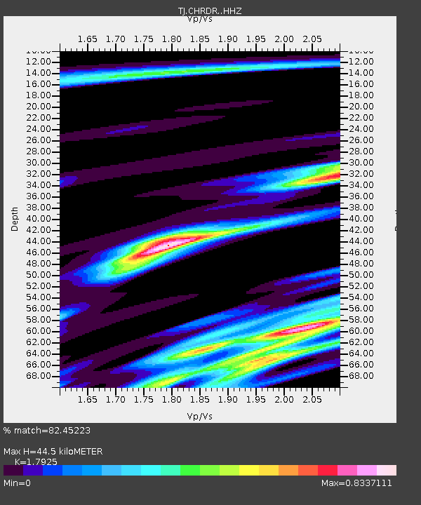
| Estimated Moho Depth: |
44.5 km |
| Estimated Crust Vp/Vs: |
1.79 |
| Assumed Crust Vp: |
6.316 km/s |
| Estimated Crust Vs: |
3.523 km/s |
| Estimated Crust Poisson's Ratio: |
0.27 |
|
| Radial Match: |
82.45223 % |
| Radial Bump: |
400 |
| Transverse Match: |
74.718704 % |
| Transverse Bump: |
400 |
| SOD ConfigId: |
13570011 |
| Insert Time: |
2019-04-29 09:38:29.930 +0000 |
| GWidth: |
2.5 |
| Max Bumps: |
400 |
| Tol: |
0.001 |
|

Signal To Noise
| Channel | StoN | STA | LTA |
| TJ:CHRDR: :HHZ:20171208T10:01:41.240002Z | 4.1818624 | 1.148315E-6 | 2.7459419E-7 |
| TJ:CHRDR: :HHN:20171208T10:01:41.240002Z | 1.0459133 | 2.5094602E-7 | 2.3993002E-7 |
| TJ:CHRDR: :HHE:20171208T10:01:41.240002Z | 1.3415244 | 5.296429E-7 | 3.9480676E-7 |
| Arrivals |
| Ps | 5.8 SECOND |
| PpPs | 19 SECOND |
| PsPs/PpSs | 25 SECOND |


