You are here: Home > Network List > TJ - Tajikistan National Seismic Network Stations List
> Station GARM Garm, Tajikistan > Earthquake Result Viewer
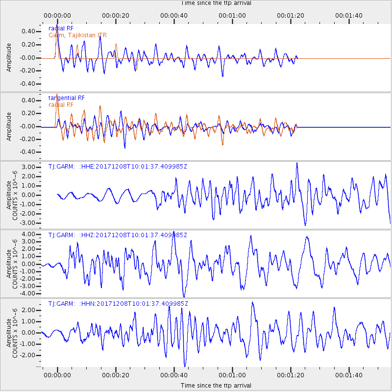
GARM Garm, Tajikistan - Earthquake Result Viewer
*The percent match for this event was below the threshold and hence no stack was calculated.
| Earthquake location: |
W. Caroline Islands, Micronesia |
| Earthquake latitude/longitude: |
10.0/140.1 |
| Earthquake time(UTC): |
2017/12/08 (342) 09:51:10 GMT |
| Earthquake Depth: |
20 km |
| Earthquake Magnitude: |
6.4 Mww |
| Earthquake Catalog/Contributor: |
NEIC PDE/us |
|
| Network: |
TJ Tajikistan National Seismic Network |
| Station: |
GARM Garm, Tajikistan |
| Lat/Lon: |
39.00 N/70.32 E |
| Elevation: |
1305 m |
|
| Distance: |
68.1 deg |
| Az: |
307.977 deg |
| Baz: |
94.851 deg |
| Ray Param: |
$rayparam |
*The percent match for this event was below the threshold and hence was not used in the summary stack. |
|
| Radial Match: |
77.560555 % |
| Radial Bump: |
400 |
| Transverse Match: |
80.41065 % |
| Transverse Bump: |
400 |
| SOD ConfigId: |
13570011 |
| Insert Time: |
2019-04-29 09:38:30.360 +0000 |
| GWidth: |
2.5 |
| Max Bumps: |
400 |
| Tol: |
0.001 |
|
Signal To Noise
| Channel | StoN | STA | LTA |
| TJ:GARM: :HHZ:20171208T10:01:37.409985Z | 7.866602 | 9.774877E-7 | 1.2425792E-7 |
| TJ:GARM: :HHN:20171208T10:01:37.409985Z | 1.2286191 | 3.6753437E-7 | 2.991443E-7 |
| TJ:GARM: :HHE:20171208T10:01:37.409985Z | 1.5021614 | 5.761453E-7 | 3.835442E-7 |
| Arrivals |
| Ps | |
| PpPs | |
| PsPs/PpSs | |


