You are here: Home > Network List > UW - Pacific Northwest Regional Seismic Network Stations List
> Station LEBA Lebam, WA, USA > Earthquake Result Viewer
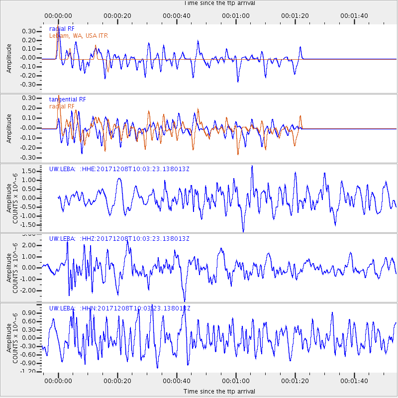
LEBA Lebam, WA, USA - Earthquake Result Viewer
*The percent match for this event was below the threshold and hence no stack was calculated.
| Earthquake location: |
W. Caroline Islands, Micronesia |
| Earthquake latitude/longitude: |
10.0/140.1 |
| Earthquake time(UTC): |
2017/12/08 (342) 09:51:10 GMT |
| Earthquake Depth: |
20 km |
| Earthquake Magnitude: |
6.4 Mww |
| Earthquake Catalog/Contributor: |
NEIC PDE/us |
|
| Network: |
UW Pacific Northwest Regional Seismic Network |
| Station: |
LEBA Lebam, WA, USA |
| Lat/Lon: |
46.55 N/123.56 W |
| Elevation: |
73 m |
|
| Distance: |
87.1 deg |
| Az: |
43.385 deg |
| Baz: |
281.403 deg |
| Ray Param: |
$rayparam |
*The percent match for this event was below the threshold and hence was not used in the summary stack. |
|
| Radial Match: |
68.24527 % |
| Radial Bump: |
400 |
| Transverse Match: |
61.3756 % |
| Transverse Bump: |
400 |
| SOD ConfigId: |
13570011 |
| Insert Time: |
2019-04-29 09:39:11.444 +0000 |
| GWidth: |
2.5 |
| Max Bumps: |
400 |
| Tol: |
0.001 |
|
Signal To Noise
| Channel | StoN | STA | LTA |
| UW:LEBA: :HHZ:20171208T10:03:23.138013Z | 3.9671874 | 9.964319E-7 | 2.5116836E-7 |
| UW:LEBA: :HHN:20171208T10:03:23.138013Z | 1.1965448 | 4.5291378E-7 | 3.7851802E-7 |
| UW:LEBA: :HHE:20171208T10:03:23.138013Z | 0.681663 | 3.1722328E-7 | 4.6536672E-7 |
| Arrivals |
| Ps | |
| PpPs | |
| PsPs/PpSs | |


