You are here: Home > Network List > TA - USArray Transportable Network (new EarthScope stations) Stations List
> Station P20A De Beque, CO, USA > Earthquake Result Viewer
P20A De Beque, CO, USA - Earthquake Result Viewer
| Earthquake location: |
Kermadec Islands Region |
| Earthquake latitude/longitude: |
-27.4/-176.3 |
| Earthquake time(UTC): |
2009/02/18 (049) 21:53:45 GMT |
| Earthquake Depth: |
25 km |
| Earthquake Magnitude: |
6.8 MB, 7.2 MS, 6.9 MW, 6.9 MW |
| Earthquake Catalog/Contributor: |
WHDF/NEIC |
|
| Network: |
TA USArray Transportable Network (new EarthScope stations) |
| Station: |
P20A De Beque, CO, USA |
| Lat/Lon: |
39.50 N/108.39 W |
| Elevation: |
1738 m |
|
| Distance: |
91.8 deg |
| Az: |
45.843 deg |
| Baz: |
235.51 deg |
| Ray Param: |
0.041545045 |
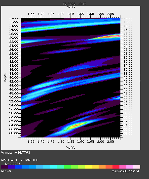
| Estimated Moho Depth: |
18.75 km |
| Estimated Crust Vp/Vs: |
2.10 |
| Assumed Crust Vp: |
6.291 km/s |
| Estimated Crust Vs: |
2.999 km/s |
| Estimated Crust Poisson's Ratio: |
0.35 |
|
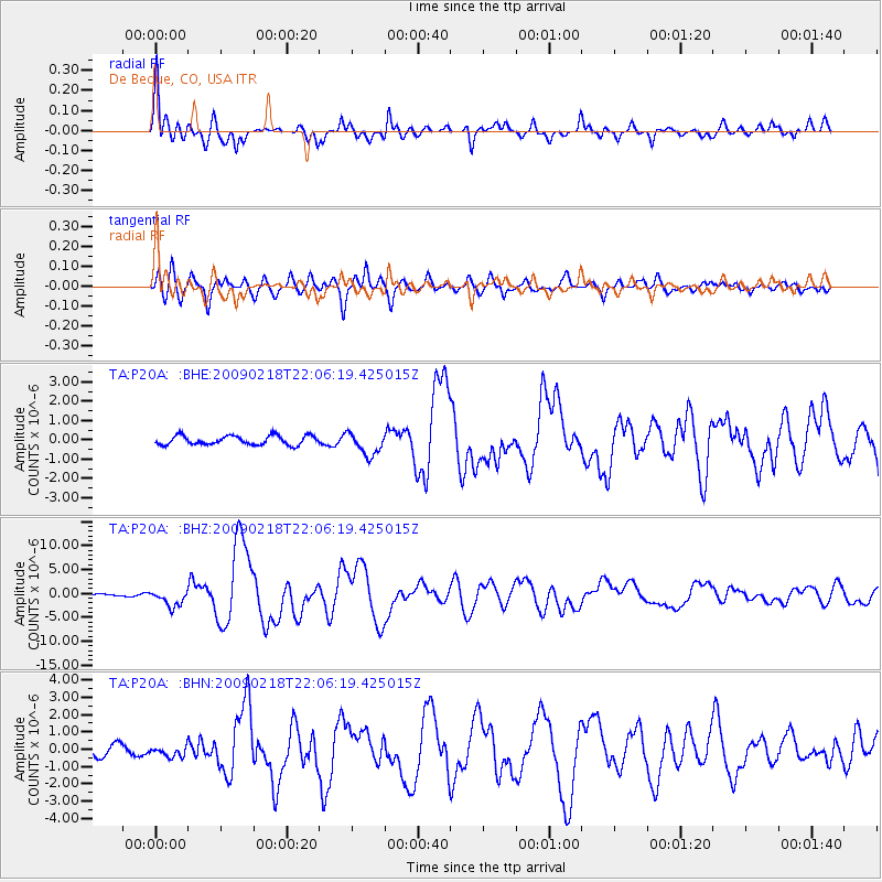
| Radial Match: |
86.7793 % |
| Radial Bump: |
400 |
| Transverse Match: |
88.723175 % |
| Transverse Bump: |
400 |
| SOD ConfigId: |
2658 |
| Insert Time: |
2010-03-06 07:18:44.688 +0000 |
| GWidth: |
2.5 |
| Max Bumps: |
400 |
| Tol: |
0.001 |
|
Signal To Noise
| Channel | StoN | STA | LTA |
| TA:P20A: :BHZ:20090218T22:06:19.425015Z | 5.0921826 | 1.7131106E-6 | 3.364197E-7 |
| TA:P20A: :BHN:20090218T22:06:19.425015Z | 0.77878094 | 3.0160757E-7 | 3.8728166E-7 |
| TA:P20A: :BHE:20090218T22:06:19.425015Z | 2.5619776 | 5.972058E-7 | 2.3310346E-7 |
| Arrivals |
| Ps | 3.3 SECOND |
| PpPs | 9.1 SECOND |
| PsPs/PpSs | 12 SECOND |


