You are here: Home > Network List > TA - USArray Transportable Network (new EarthScope stations) Stations List
> Station P20A De Beque, CO, USA > Earthquake Result Viewer
P20A De Beque, CO, USA - Earthquake Result Viewer

| Earthquake location: |
Vanuatu Islands |
| Earthquake latitude/longitude: |
-13.0/166.5 |
| Earthquake time(UTC): |
2009/10/07 (280) 22:03:14 GMT |
| Earthquake Depth: |
45 km |
| Earthquake Magnitude: |
6.4 MB, 7.3 MS, 7.6 MW, 7.7 MW |
| Earthquake Catalog/Contributor: |
WHDF/NEIC |
|
| Network: |
TA USArray Transportable Network (new EarthScope stations) |
| Station: |
P20A De Beque, CO, USA |
| Lat/Lon: |
39.50 N/108.39 W |
| Elevation: |
1738 m |
|
| Distance: |
94.4 deg |
| Az: |
50.642 deg |
| Baz: |
256.912 deg |
| Ray Param: |
0.041023917 |
| Estimated Moho Depth: |
12.75 km |
| Estimated Crust Vp/Vs: |
2.04 |
| Assumed Crust Vp: |
6.291 km/s |
| Estimated Crust Vs: |
3.091 km/s |
| Estimated Crust Poisson's Ratio: |
0.34 |
|
| Radial Match: |
93.499084 % |
| Radial Bump: |
392 |
| Transverse Match: |
75.51016 % |
| Transverse Bump: |
400 |
| SOD ConfigId: |
2622 |
| Insert Time: |
2010-03-06 07:19:08.655 +0000 |
| GWidth: |
2.5 |
| Max Bumps: |
400 |
| Tol: |
0.001 |
|
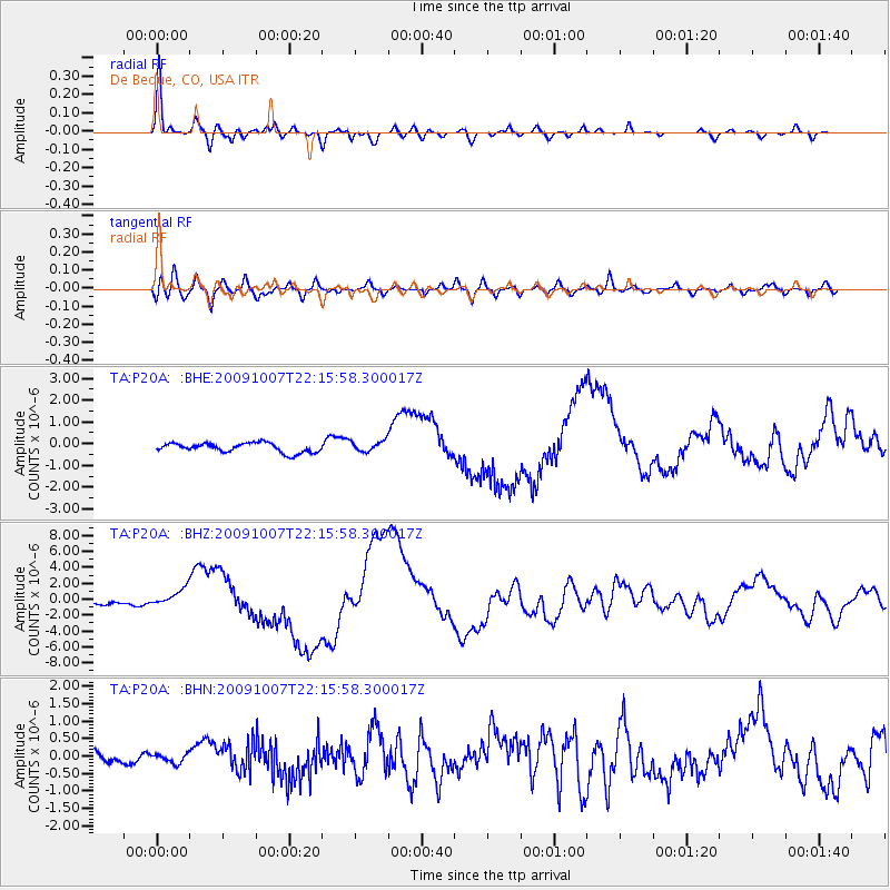
Signal To Noise
| Channel | StoN | STA | LTA |
| TA:P20A: :BHZ:20091007T22:15:58.300017Z | 5.0643177 | 1.1072779E-6 | 2.1864305E-7 |
| TA:P20A: :BHN:20091007T22:15:58.300017Z | 0.40722007 | 1.2571503E-7 | 3.0871524E-7 |
| TA:P20A: :BHE:20091007T22:15:58.300017Z | 1.16142 | 2.490049E-7 | 2.1439695E-7 |
| Arrivals |
| Ps | 2.1 SECOND |
| PpPs | 6.0 SECOND |
| PsPs/PpSs | 8.2 SECOND |


