You are here: Home > Network List > CI - Caltech Regional Seismic Network Stations List
> Station MPP McPhearson Peak > Earthquake Result Viewer
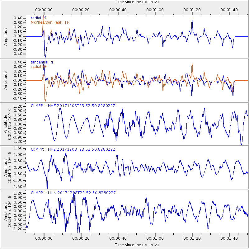
MPP McPhearson Peak - Earthquake Result Viewer
*The percent match for this event was below the threshold and hence no stack was calculated.
| Earthquake location: |
Tonga Islands |
| Earthquake latitude/longitude: |
-16.1/-174.0 |
| Earthquake time(UTC): |
2017/12/08 (342) 23:42:09 GMT |
| Earthquake Depth: |
117 km |
| Earthquake Magnitude: |
5.7 mb |
| Earthquake Catalog/Contributor: |
NEIC PDE/us |
|
| Network: |
CI Caltech Regional Seismic Network |
| Station: |
MPP McPhearson Peak |
| Lat/Lon: |
34.89 N/119.81 W |
| Elevation: |
1739 m |
|
| Distance: |
72.2 deg |
| Az: |
44.408 deg |
| Baz: |
234.901 deg |
| Ray Param: |
$rayparam |
*The percent match for this event was below the threshold and hence was not used in the summary stack. |
|
| Radial Match: |
48.85577 % |
| Radial Bump: |
400 |
| Transverse Match: |
56.293964 % |
| Transverse Bump: |
400 |
| SOD ConfigId: |
13570011 |
| Insert Time: |
2019-04-29 09:42:36.892 +0000 |
| GWidth: |
2.5 |
| Max Bumps: |
400 |
| Tol: |
0.001 |
|
Signal To Noise
| Channel | StoN | STA | LTA |
| CI:MPP: :HHZ:20171208T23:52:50.828022Z | 3.0609605 | 6.372682E-7 | 2.0819223E-7 |
| CI:MPP: :HHN:20171208T23:52:50.828022Z | 0.9438597 | 4.5604725E-7 | 4.831727E-7 |
| CI:MPP: :HHE:20171208T23:52:50.828022Z | 0.69158185 | 3.810652E-7 | 5.510052E-7 |
| Arrivals |
| Ps | |
| PpPs | |
| PsPs/PpSs | |


