You are here: Home > Network List > TA - USArray Transportable Network (new EarthScope stations) Stations List
> Station F21K Alatna River, AK, USA > Earthquake Result Viewer
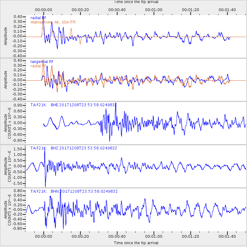
F21K Alatna River, AK, USA - Earthquake Result Viewer
*The percent match for this event was below the threshold and hence no stack was calculated.
| Earthquake location: |
Tonga Islands |
| Earthquake latitude/longitude: |
-16.1/-174.0 |
| Earthquake time(UTC): |
2017/12/08 (342) 23:42:09 GMT |
| Earthquake Depth: |
117 km |
| Earthquake Magnitude: |
5.7 mb |
| Earthquake Catalog/Contributor: |
NEIC PDE/us |
|
| Network: |
TA USArray Transportable Network (new EarthScope stations) |
| Station: |
F21K Alatna River, AK, USA |
| Lat/Lon: |
67.22 N/153.48 W |
| Elevation: |
597 m |
|
| Distance: |
84.5 deg |
| Az: |
7.865 deg |
| Baz: |
199.742 deg |
| Ray Param: |
$rayparam |
*The percent match for this event was below the threshold and hence was not used in the summary stack. |
|
| Radial Match: |
76.79824 % |
| Radial Bump: |
400 |
| Transverse Match: |
50.73108 % |
| Transverse Bump: |
400 |
| SOD ConfigId: |
13570011 |
| Insert Time: |
2019-04-29 09:45:47.260 +0000 |
| GWidth: |
2.5 |
| Max Bumps: |
400 |
| Tol: |
0.001 |
|
Signal To Noise
| Channel | StoN | STA | LTA |
| TA:F21K: :BHZ:20171208T23:53:58.024983Z | 3.5430036 | 6.076915E-7 | 1.7151874E-7 |
| TA:F21K: :BHN:20171208T23:53:58.024983Z | 2.0266585 | 3.367245E-7 | 1.6614763E-7 |
| TA:F21K: :BHE:20171208T23:53:58.024983Z | 2.143054 | 3.020126E-7 | 1.4092628E-7 |
| Arrivals |
| Ps | |
| PpPs | |
| PsPs/PpSs | |


