You are here: Home > Network List > CI - Caltech Regional Seismic Network Stations List
> Station TIN Tinemaha, Big Pine, CA, USA > Earthquake Result Viewer
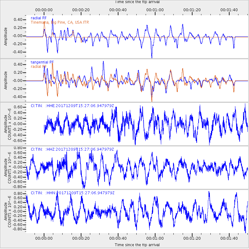
TIN Tinemaha, Big Pine, CA, USA - Earthquake Result Viewer
*The percent match for this event was below the threshold and hence no stack was calculated.
| Earthquake location: |
W. Caroline Islands, Micronesia |
| Earthquake latitude/longitude: |
10.1/140.2 |
| Earthquake time(UTC): |
2017/12/09 (343) 15:14:24 GMT |
| Earthquake Depth: |
10 km |
| Earthquake Magnitude: |
6.1 Mww |
| Earthquake Catalog/Contributor: |
NEIC PDE/us |
|
| Network: |
CI Caltech Regional Seismic Network |
| Station: |
TIN Tinemaha, Big Pine, CA, USA |
| Lat/Lon: |
37.05 N/118.23 W |
| Elevation: |
1197 m |
|
| Distance: |
93.1 deg |
| Az: |
51.711 deg |
| Baz: |
284.954 deg |
| Ray Param: |
$rayparam |
*The percent match for this event was below the threshold and hence was not used in the summary stack. |
|
| Radial Match: |
67.18948 % |
| Radial Bump: |
400 |
| Transverse Match: |
58.251263 % |
| Transverse Bump: |
400 |
| SOD ConfigId: |
13570011 |
| Insert Time: |
2019-04-29 09:50:06.988 +0000 |
| GWidth: |
2.5 |
| Max Bumps: |
400 |
| Tol: |
0.001 |
|
Signal To Noise
| Channel | StoN | STA | LTA |
| CI:TIN: :HHZ:20171209T15:27:06.947979Z | 0.8010057 | 1.5185094E-7 | 1.8957535E-7 |
| CI:TIN: :HHN:20171209T15:27:06.947979Z | 0.66589266 | 1.7836318E-7 | 2.6785574E-7 |
| CI:TIN: :HHE:20171209T15:27:06.947979Z | 0.8797741 | 1.5484396E-7 | 1.7600424E-7 |
| Arrivals |
| Ps | |
| PpPs | |
| PsPs/PpSs | |


