You are here: Home > Network List > TA - USArray Transportable Network (new EarthScope stations) Stations List
> Station D23K Nanushuk River, AK USA > Earthquake Result Viewer
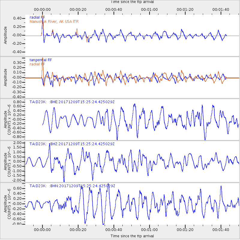
D23K Nanushuk River, AK USA - Earthquake Result Viewer
*The percent match for this event was below the threshold and hence no stack was calculated.
| Earthquake location: |
W. Caroline Islands, Micronesia |
| Earthquake latitude/longitude: |
10.1/140.2 |
| Earthquake time(UTC): |
2017/12/09 (343) 15:14:24 GMT |
| Earthquake Depth: |
10 km |
| Earthquake Magnitude: |
6.1 Mww |
| Earthquake Catalog/Contributor: |
NEIC PDE/us |
|
| Network: |
TA USArray Transportable Network (new EarthScope stations) |
| Station: |
D23K Nanushuk River, AK USA |
| Lat/Lon: |
68.97 N/150.68 W |
| Elevation: |
406 m |
|
| Distance: |
73.2 deg |
| Az: |
20.631 deg |
| Baz: |
253.955 deg |
| Ray Param: |
$rayparam |
*The percent match for this event was below the threshold and hence was not used in the summary stack. |
|
| Radial Match: |
73.316055 % |
| Radial Bump: |
400 |
| Transverse Match: |
74.16517 % |
| Transverse Bump: |
400 |
| SOD ConfigId: |
13570011 |
| Insert Time: |
2019-04-29 09:52:15.679 +0000 |
| GWidth: |
2.5 |
| Max Bumps: |
400 |
| Tol: |
0.001 |
|
Signal To Noise
| Channel | StoN | STA | LTA |
| TA:D23K: :BHZ:20171209T15:25:24.425029Z | 3.0769255 | 7.1785985E-7 | 2.3330428E-7 |
| TA:D23K: :BHN:20171209T15:25:24.425029Z | 0.49518725 | 1.0244868E-7 | 2.0688877E-7 |
| TA:D23K: :BHE:20171209T15:25:24.425029Z | 0.98505706 | 2.4629344E-7 | 2.5002961E-7 |
| Arrivals |
| Ps | |
| PpPs | |
| PsPs/PpSs | |


