You are here: Home > Network List > TA - USArray Transportable Network (new EarthScope stations) Stations List
> Station J20K Nowitna River, AK, USA > Earthquake Result Viewer
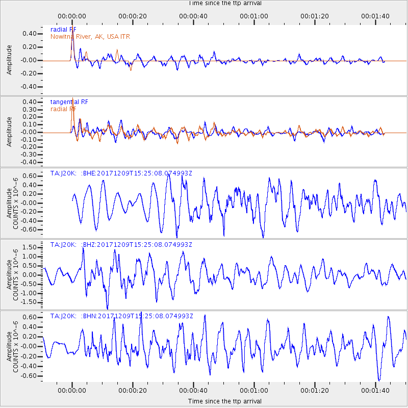
J20K Nowitna River, AK, USA - Earthquake Result Viewer
*The percent match for this event was below the threshold and hence no stack was calculated.
| Earthquake location: |
W. Caroline Islands, Micronesia |
| Earthquake latitude/longitude: |
10.1/140.2 |
| Earthquake time(UTC): |
2017/12/09 (343) 15:14:24 GMT |
| Earthquake Depth: |
10 km |
| Earthquake Magnitude: |
6.1 Mww |
| Earthquake Catalog/Contributor: |
NEIC PDE/us |
|
| Network: |
TA USArray Transportable Network (new EarthScope stations) |
| Station: |
J20K Nowitna River, AK, USA |
| Lat/Lon: |
64.18 N/154.15 W |
| Elevation: |
314 m |
|
| Distance: |
70.5 deg |
| Az: |
25.047 deg |
| Baz: |
252.153 deg |
| Ray Param: |
$rayparam |
*The percent match for this event was below the threshold and hence was not used in the summary stack. |
|
| Radial Match: |
64.55989 % |
| Radial Bump: |
366 |
| Transverse Match: |
59.177803 % |
| Transverse Bump: |
400 |
| SOD ConfigId: |
13570011 |
| Insert Time: |
2019-04-29 09:52:46.878 +0000 |
| GWidth: |
2.5 |
| Max Bumps: |
400 |
| Tol: |
0.001 |
|
Signal To Noise
| Channel | StoN | STA | LTA |
| TA:J20K: :BHZ:20171209T15:25:08.074993Z | 2.1864831 | 5.842624E-7 | 2.6721563E-7 |
| TA:J20K: :BHN:20171209T15:25:08.074993Z | 0.99362546 | 1.729996E-7 | 1.7410947E-7 |
| TA:J20K: :BHE:20171209T15:25:08.074993Z | 1.812778 | 4.567417E-7 | 2.5195678E-7 |
| Arrivals |
| Ps | |
| PpPs | |
| PsPs/PpSs | |


