You are here: Home > Network List > TJ - Tajikistan National Seismic Network Stations List
> Station GARM Garm, Tajikistan > Earthquake Result Viewer
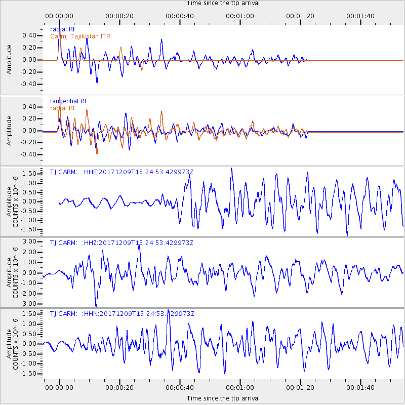
GARM Garm, Tajikistan - Earthquake Result Viewer
*The percent match for this event was below the threshold and hence no stack was calculated.
| Earthquake location: |
W. Caroline Islands, Micronesia |
| Earthquake latitude/longitude: |
10.1/140.2 |
| Earthquake time(UTC): |
2017/12/09 (343) 15:14:24 GMT |
| Earthquake Depth: |
10 km |
| Earthquake Magnitude: |
6.1 Mww |
| Earthquake Catalog/Contributor: |
NEIC PDE/us |
|
| Network: |
TJ Tajikistan National Seismic Network |
| Station: |
GARM Garm, Tajikistan |
| Lat/Lon: |
39.00 N/70.32 E |
| Elevation: |
1305 m |
|
| Distance: |
68.1 deg |
| Az: |
307.946 deg |
| Baz: |
94.733 deg |
| Ray Param: |
$rayparam |
*The percent match for this event was below the threshold and hence was not used in the summary stack. |
|
| Radial Match: |
78.70347 % |
| Radial Bump: |
400 |
| Transverse Match: |
76.23698 % |
| Transverse Bump: |
400 |
| SOD ConfigId: |
13570011 |
| Insert Time: |
2019-04-29 09:53:08.538 +0000 |
| GWidth: |
2.5 |
| Max Bumps: |
400 |
| Tol: |
0.001 |
|
Signal To Noise
| Channel | StoN | STA | LTA |
| TJ:GARM: :HHZ:20171209T15:24:53.429973Z | 2.8469503 | 4.5829879E-7 | 1.6097884E-7 |
| TJ:GARM: :HHN:20171209T15:24:53.429973Z | 0.9425048 | 1.6741234E-7 | 1.7762493E-7 |
| TJ:GARM: :HHE:20171209T15:24:53.429973Z | 0.9486267 | 1.6078184E-7 | 1.6948906E-7 |
| Arrivals |
| Ps | |
| PpPs | |
| PsPs/PpSs | |


