You are here: Home > Network List > AU - Australian Seismological Centre Stations List
> Station CTA Charters Towers, Queensland > Earthquake Result Viewer
CTA Charters Towers, Queensland - Earthquake Result Viewer
| Earthquake location: |
Tonga Islands |
| Earthquake latitude/longitude: |
-20.8/-173.6 |
| Earthquake time(UTC): |
2017/12/11 (345) 10:50:00 GMT |
| Earthquake Depth: |
10 km |
| Earthquake Magnitude: |
5.6 mb |
| Earthquake Catalog/Contributor: |
NEIC PDE/us |
|
| Network: |
AU Australian Seismological Centre |
| Station: |
CTA Charters Towers, Queensland |
| Lat/Lon: |
20.09 S/146.25 E |
| Elevation: |
426 m |
|
| Distance: |
37.6 deg |
| Az: |
263.817 deg |
| Baz: |
98.288 deg |
| Ray Param: |
0.07606598 |
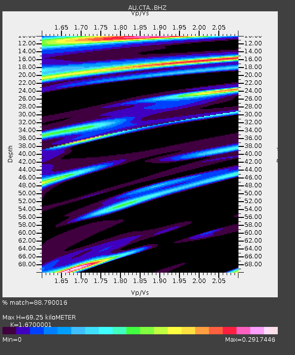
| Estimated Moho Depth: |
69.25 km |
| Estimated Crust Vp/Vs: |
1.67 |
| Assumed Crust Vp: |
6.522 km/s |
| Estimated Crust Vs: |
3.905 km/s |
| Estimated Crust Poisson's Ratio: |
0.22 |
|
| Radial Match: |
88.790016 % |
| Radial Bump: |
214 |
| Transverse Match: |
65.05718 % |
| Transverse Bump: |
400 |
| SOD ConfigId: |
13570011 |
| Insert Time: |
2019-04-29 09:55:06.567 +0000 |
| GWidth: |
2.5 |
| Max Bumps: |
400 |
| Tol: |
0.001 |
|

Signal To Noise
| Channel | StoN | STA | LTA |
| AU:CTA: :BHZ:20171211T10:56:43.725001Z | 8.585256 | 1.315597E-6 | 1.5323911E-7 |
| AU:CTA: :BHN:20171211T10:56:43.725001Z | 0.9363272 | 1.183369E-7 | 1.2638412E-7 |
| AU:CTA: :BHE:20171211T10:56:43.725001Z | 7.4416547 | 6.930856E-7 | 9.313595E-8 |
| Arrivals |
| Ps | 7.7 SECOND |
| PpPs | 26 SECOND |
| PsPs/PpSs | 34 SECOND |


