You are here: Home > Network List > AZ - ANZA Regional Network Stations List
> Station LVA2 AZ.LVA2 > Earthquake Result Viewer
LVA2 AZ.LVA2 - Earthquake Result Viewer
*The percent match for this event was below the threshold and hence no stack was calculated.
| Earthquake location: |
Tonga Islands |
| Earthquake latitude/longitude: |
-20.8/-173.6 |
| Earthquake time(UTC): |
2017/12/11 (345) 10:50:00 GMT |
| Earthquake Depth: |
10 km |
| Earthquake Magnitude: |
5.6 mb |
| Earthquake Catalog/Contributor: |
NEIC PDE/us |
|
| Network: |
AZ ANZA Regional Network |
| Station: |
LVA2 AZ.LVA2 |
| Lat/Lon: |
33.35 N/116.56 W |
| Elevation: |
1435 m |
|
| Distance: |
76.5 deg |
| Az: |
46.225 deg |
| Baz: |
233.81 deg |
| Ray Param: |
$rayparam |
*The percent match for this event was below the threshold and hence was not used in the summary stack. |
|
| Radial Match: |
67.13683 % |
| Radial Bump: |
400 |
| Transverse Match: |
66.14955 % |
| Transverse Bump: |
400 |
| SOD ConfigId: |
13570011 |
| Insert Time: |
2019-04-29 09:55:33.944 +0000 |
| GWidth: |
2.5 |
| Max Bumps: |
400 |
| Tol: |
0.001 |
|
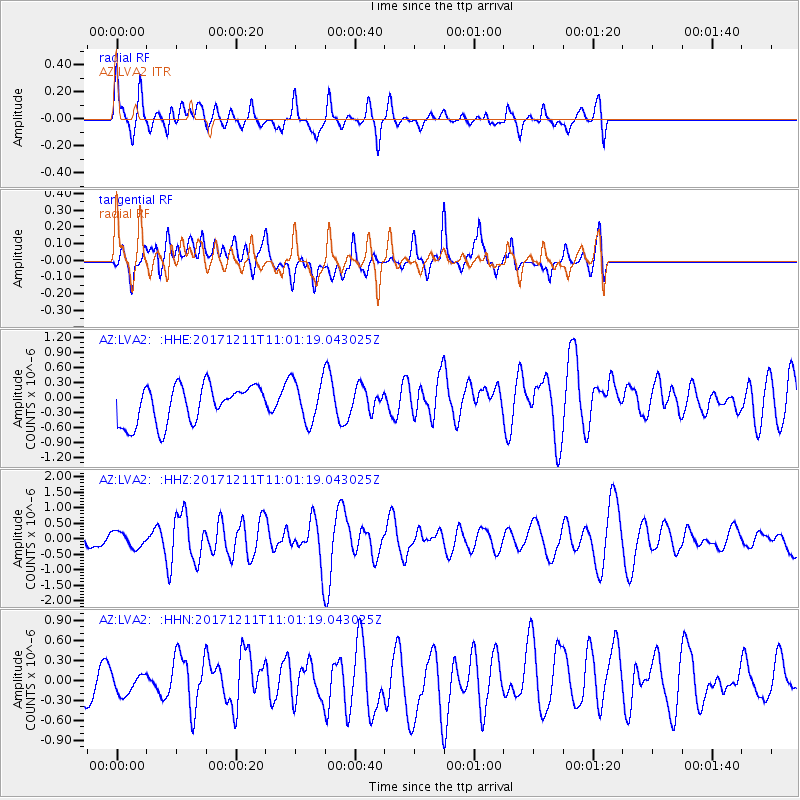
Signal To Noise
| Channel | StoN | STA | LTA |
| AZ:LVA2: :HHZ:20171211T11:01:19.043025Z | 1.1429708 | 2.4852804E-7 | 2.174404E-7 |
| AZ:LVA2: :HHN:20171211T11:01:19.043025Z | 0.79640675 | 2.1922057E-7 | 2.7526207E-7 |
| AZ:LVA2: :HHE:20171211T11:01:19.043025Z | 1.1185472 | 4.2373222E-7 | 3.7882373E-7 |
| Arrivals |
| Ps | |
| PpPs | |
| PsPs/PpSs | |


