You are here: Home > Network List > TA - USArray Transportable Network (new EarthScope stations) Stations List
> Station P20A De Beque, CO, USA > Earthquake Result Viewer
P20A De Beque, CO, USA - Earthquake Result Viewer
*The percent match for this event was below the threshold and hence no stack was calculated.
| Earthquake location: |
Mariana Islands |
| Earthquake latitude/longitude: |
19.1/145.8 |
| Earthquake time(UTC): |
2008/12/02 (337) 12:31:43 GMT |
| Earthquake Depth: |
137 km |
| Earthquake Magnitude: |
5.9 MB, 5.9 MW, 5.9 MW |
| Earthquake Catalog/Contributor: |
WHDF/NEIC |
|
| Network: |
TA USArray Transportable Network (new EarthScope stations) |
| Station: |
P20A De Beque, CO, USA |
| Lat/Lon: |
39.50 N/108.39 W |
| Elevation: |
1738 m |
|
| Distance: |
89.6 deg |
| Az: |
48.098 deg |
| Baz: |
294.549 deg |
| Ray Param: |
$rayparam |
*The percent match for this event was below the threshold and hence was not used in the summary stack. |
|
| Radial Match: |
48.583492 % |
| Radial Bump: |
400 |
| Transverse Match: |
48.658432 % |
| Transverse Bump: |
400 |
| SOD ConfigId: |
2658 |
| Insert Time: |
2010-03-06 07:21:42.223 +0000 |
| GWidth: |
2.5 |
| Max Bumps: |
400 |
| Tol: |
0.001 |
|
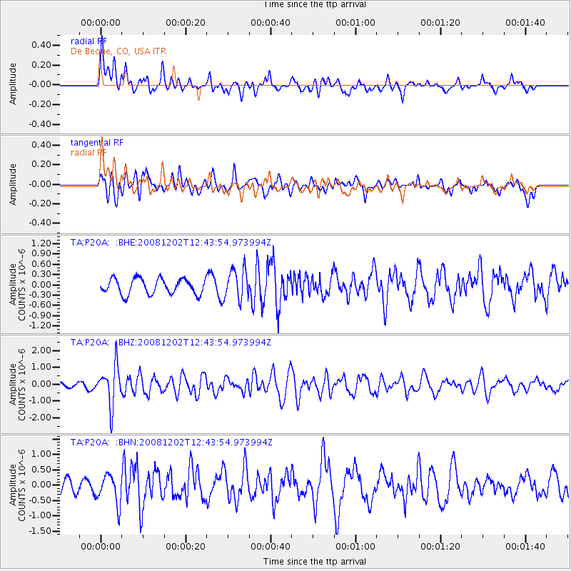
Signal To Noise
| Channel | StoN | STA | LTA |
| TA:P20A: :BHZ:20081202T12:43:54.973994Z | 4.4566016 | 1.198258E-6 | 2.6887258E-7 |
| TA:P20A: :BHN:20081202T12:43:54.973994Z | 1.9946406 | 4.7778303E-7 | 2.395334E-7 |
| TA:P20A: :BHE:20081202T12:43:54.973994Z | 1.9374356 | 4.3598445E-7 | 2.250317E-7 |
| Arrivals |
| Ps | |
| PpPs | |
| PsPs/PpSs | |


